Search

Search Results

Carte de l'ile de Java

eventc.1850

location_onIndonesia

Map of Java and Madura divided into administrative districts, and featuring mountains, settlements and major roads. There is an inset map of the port city of Batavia (Jakarta) and its surrounding fields and countryside.

Carte de l'ile de Java

eventc.1850

location_onIndonesia

Map of Java and Madura divided into administrative districts, and featuring mountains, settlements and major roads. There is an inset map of the port city of Batavia (Jakarta) and its surrounding fields and countryside.

Carte de l'île de Java

event1847

location_onIndonesia

This map uses hachures—short lines/dashes that give a sense of the shape and steepness of terrain—to show Java’s mountains. There are also two side views (elevations) of the mountains showing the heights of various road routes across the island.

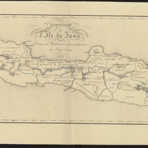
Esquisse de l'ile de Java: divisée en Residences avec indication des chefs-lieux

event1833

location_onIndonesia

Map of Java divided into Dutch administrative areas (‘residencies’), and the Empire of Soerakarta and Kingdom of Djokjakarta, which were under indigenous rule (a note records the territories these indigenous areas lost in the Java War (1825–1830)).

Carte des environs de Batavia = Kaart van de buitenstreeken van Batavia

eventc.1772-1780

location_onIndonesia

This late 18th century map of Batavia (Jakarta) focusses on the network of canals and rivers surrounding the city, as well as the many fields and plantations, including rice fields (‘Champ de Ris’) and sugarcane (‘Cannes de Sucre’).

close

  • Filter from 1772 to 1850

Current results range from 1772 to 1850