Search Results
![](https://historicalmaps.yale-nus.edu.sg/rails/active_storage/representations/eyJfcmFpbHMiOnsibWVzc2FnZSI6IkJBaHBBY3M9IiwiZXhwIjpudWxsLCJwdXIiOiJibG9iX2lkIn19--230833c7ee81289c92f6093244601b1a513b82e9/eyJfcmFpbHMiOnsibWVzc2FnZSI6IkJBaDdCam9MY21WemFYcGxTU0lNTkRBd2VETXdNQVk2QmtWVSIsImV4cCI6bnVsbCwicHVyIjoidmFyaWF0aW9uIn19--bc467f5637e8b6d3bfb826116f92b6bfedfbf03a/leiden-2017185.jpeg)
Atlas van Nederlandsch Oost-Indië
c.1897-1904
Indonesia
Very detailed atlas of the entire Dutch East Indies, over 16 map sheets, with a cover and overview map. Includes topographic maps, inset maps of cities and islands, and maps featuring land and sea routes, languages, geology, colonial territory etc.
![](https://historicalmaps.yale-nus.edu.sg/rails/active_storage/representations/eyJfcmFpbHMiOnsibWVzc2FnZSI6IkJBaHBBallFIiwiZXhwIjpudWxsLCJwdXIiOiJibG9iX2lkIn19--7161e5ac88878ba61a8863643bb3b72e92c5032a/eyJfcmFpbHMiOnsibWVzc2FnZSI6IkJBaDdCam9MY21WemFYcGxTU0lNTkRBd2VETXdNQVk2QmtWVSIsImV4cCI6bnVsbCwicHVyIjoidmFyaWF0aW9uIn19--bc467f5637e8b6d3bfb826116f92b6bfedfbf03a/leiden-2012477.jpeg)
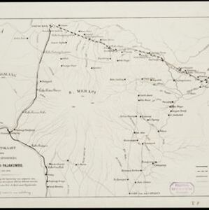
Overzichtskaart van den ontworpen spoorweg Fort de Kock-Pajakombo
1894
Indonesia
A map of railway lines between Fort de Kock (Bukittinggi) and Pajakombo (Payakumbuh) in western Sumatra. The map includes existing line, planned line and rack railway line (a line with a rack and pinion system so it can operate on steep slopes).
- [remove]Bukittinggi4
- Dutch East Indies4
- Fort de Kock4
- [remove]Sumatra4
- Padang2
- Payakumbuh2
- Ambon1
- Banda Aceh1
- Banda Eilanden1
- Banda Islands1
- Bandjarmasin1
- Bangka1
- more Detailed Location »
- Railway/Tramway4
- River4
- [remove]Road4
- Path3
- Bridge1
- Canal1
- Postal Route1
- Telegraph/Telephone1