Search

Search Results

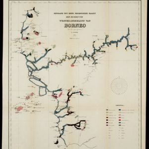
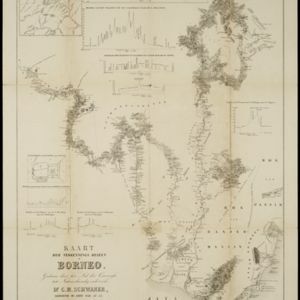
Algemeene Kaart van het Nederlandsch Gebied op het Eiland Borneo: No. III

event1859

location_onIndonesia

Map of the Dutch colonial administrative regions of southeast Borneo, featuring mountains, rivers and settlements. (One of four sheets covering Borneo from ‘Algemeene Atlas van Nederlandsche Indie [General Atlas of the Dutch East Indies]’.)

Algemeene Kaart van het Nederlandsch Gebied op het Eiland Borneo: No. IV

event1859

location_onIndonesia

Map of the Dutch colonial administrative regions of northeast Borneo, featuring mountains, rivers and settlements. (One of four sheets covering Borneo from ‘Algemeene Atlas van Nederlandsche Indie [General Atlas of the Dutch East Indies]’.)

Bijdrage tot eene geologische kaart der residentie Westerafdeeling van Borneo

event1858

location_onIndonesia

A geological map of western Borneo made by a mine engineer, showing the types of soil, coal, clay, and rock (limestone, sandstone, granite, basalt), as well as gold, diamonds, tin, copper and iron found along the rivers.

Kaart van het Eiland Soembawa

event1856

location_onIndonesia, East Timor

Map of the island of Soembawa (Sumbawa) featuring an inset map of the 1815 eruption of Mount Tambora, and an elevation showing heights of mountains. (From ‘Algemeene Atlas van Nederlandsche Indie [General Atlas of the Dutch East Indies]’.)

Nederlandsche overzeesche bezittingen / Oost-Indië

event1856

location_onBrunei, East Timor, Indonesia, Malaysia, Singapore

Map of the East Indies, showing Dutch colonial territory (Dutch East Indies) in the mid-19th century. Coloured borders are used to highlight internal administrative regions. Three inset maps show other Dutch territories outside Southeast Asia.

School-kaart van Oost-Indië

event1854

location_onIndonesia

One sheet (of eight) from a map of the Dutch East Indies, used in schools in the mid-19th century. Java is divided into residencies, and mountains—represented by short lines/dashes called hachures—major roads and settlements are shown.

Algemeene Atlas van Nederlandsche Indie

eventc.1853-1862

location_onIndonesia

Atlas featuring over 60 detailed maps of the Dutch East Indies: 24 maps cover Java; the remainder cover the rest of the Dutch East Indies. There are three index maps. (All the maps in this atlas are also presented separately on this platform.)

Kaart der verkennings reizen op Borneo

event1853

location_onIndonesia

Map charting expeditions in southern and eastern Borneo by the German geologist Carl Schwaner in the 1840s. Includes an inset map of rivers and watersheds in central Borneo, nine cross sections of the heights of rivers, and a plan of a gold mine.

Nederlandsch Oost-Indië / Java

eventc.1850

location_onBrunei, East Timor, Indonesia, Malaysia, Philippines, Singapore, Thailand

Two maps of the Dutch East Indies: one of the whole region, and one of Java alone. Both are divided into administrative regions—e.g. Java is divided into regencies—with coloured borders.

Nederlandsche bezittingen buiten Europa

eventc.1850

location_onBrunei, East Timor, Indonesia, Malaysia, Singapore

Map of the East Indies, showing Dutch colonial territory (Dutch East Indies) in the mid-19th century. Three inset maps show other Dutch territories outside Southeast Asia.

Nederlandsch Oost-Indië / Java

eventc.1850

location_onBrunei, East Timor, Indonesia, Malaysia, Philippines, Singapore, Thailand

Two maps of the Dutch East Indies: one of the whole region, and one of Java alone. Both are divided into administrative regions—e.g. Java is divided into regencies—with coloured borders.

close