
Search Results


Kaart van zuid Celebes mit uitzondering van het rijk Gowa
1888
Indonesia
Map of the South Peninsula of Celebes (Sulawesi), spread over four sheets. It features crops (alang-alang, coffee, rice, sugarcane), fishing ponds, salt panning, routes, mountains, forests and settlements. The Gowa Regency is left blank.

Kaart van de afdeeling, eiland Saleijer (Silaijara)
1886
Indonesia
Map of Saleijer (Selayar)—an island off the south coast of Celebes (Sulawesi)—and nearby islands. Settlements and roads are shown, including a long road along the west coast which links cities marked with a Dutch flag, illustrating colonial rule.

Kaart van Zuid Celebes met uitzondering van het Rijk Gowa
1886
Indonesia
Map of the South Peninsula of Celebes (Sulawesi), spread over four sheets. It features crops (alang-alang, coffee, rice, sugarcane), fishing ponds, salt panning, routes, mountains, forests and settlements. The Gowa Regency is left blank.
Kaart aangevende den bestaande toestand met betrekking tot het rechtswezen in Ned. Indië
1883
Indonesia
This map highlights the judicial system in the Dutch East Indies (‘Nederlands-Indië’) in the late 19th century. Different colours indicate the areas of authority of the different courts of law. There is an inset map of Java.

Handelskaartje van den Nederlandsch Indischen archipel
1883
Indonesia, East Timor
This map is concerned with trade in the Dutch East Indies, highlighting useful resources such as maritime routes, railways, telegraph lines and offices, coast and harbour lights, offices of officials, areas that apply tolls and duties etc.

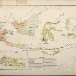
Kaart van den Indischen Archipel aangevende den bestaanden toestand met betrekking tot de Gouvernements Monopoliën van Opium en Zout
1882
Indonesia
Different levels of government monopolies are indicated on this map of the Dutch East Indies by the use of areas of colour (opium trade) and hash marks (salt trade). The inset map of Java is divided into residencies.

Kaart van de Golf van Tomini of Gorontalo en omliggende landen
1878
Indonesia
Map of the Minahasa and East peninsulas of Celebes (Sulawesi) focusing on the road system (shown by red lines). There are four inset maps, including one showing indigenous tribal areas, and a list of places with their latitude, longitude and height.
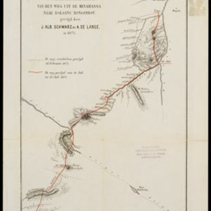
Schetskaart van den weg uit de Minahassa naar Bolaang Mongondou, gevolgd door J.Alb. Schwarz en A. de Lange, in 1875
1876
Indonesia
A map of a route taken by the Dutch Christian missionary Johannes Albert Traugott Schwarz. Over four days, accompanied by Anton de Lange, he walked from Popo (Poopo) south through the Minahasa Peninsula. The map also shows an earlier aborted route.


- Filter from 1595 to 1900
- [remove]Celebes135
- Sulawesi135
- Borneo105
- Sumatra103
- Java101
- Malay Peninsula86
- Dutch East Indies67
- Western New Guinea64
- Siam62
- Maluku Islands54
- South China Sea47
- Pegu39
- more Detailed Location »


