Search

Search Results

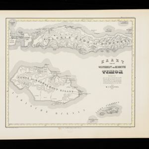
Kaart van de Westerhelft der Residentie Timor

event1860

location_onIndonesia

Map of the western half of the Dutch colonial administrative region (residency) of Timor, featuring Flores, Komodo, Sumba and Savu islands, and their straits. (From ‘Algemeene Atlas van Nederlandsche Indie [General Atlas of the Dutch East Indies]’.)

Kaart van de Oosterhelft der Residentie Timor

event1860

location_onIndonesia

Map of the eastern half of the Dutch colonial administrative region (residency) of Timor, with an inset map of its capital city and port Timorkoepang (Kupang). (From ‘Algemeene Atlas van Nederlandsche Indie [General Atlas of the Dutch East Indies]’.)

Kaart der Residentie Soerakarta

event1859

location_onIndonesia

Map of the Dutch colonial administrative region (residency) of Soerakarta (Surakarta, Java). Inset map of Surakarta city, with a military fort and two palaces. (From ‘Algemeene Atlas van Nederlandsche Indie [General Atlas of the Dutch East Indies]’.)

Kaart van de Residentie Madioen

event1859

location_onIndonesia

Map of the Dutch colonial administrative region (residency) of Madioen (Madiun, Java). A sugar factory, cinnamon shed, and indigo plant mill are marked. (From ‘Algemeene Atlas van Nederlandsche Indie [General Atlas of the Dutch East Indies]’.)

Kaart van de Assistent-Residentie Patjitan

event1859

location_onIndonesia

Map of part of the Dutch colonial administrative region of Patjitan (Pacitan, Java). Temple ruins, and a fort in the town of Patjitan, are marked. (From ‘Algemeene Atlas van Nederlandsche Indie [General Atlas of the Dutch East Indies]’.)

Algemeene Kaart van het Nederlandsch Gebied op het Eiland Borneo: No. I

event1859

location_on-

Map of the Dutch colonial administrative regions of western Borneo, featuring mountains, rivers and settlements. (One of four sheets covering Borneo from ‘Algemeene Atlas van Nederlandsche Indie [General Atlas of the Dutch East Indies]’.)

Algemeene Kaart van het Nederlandsch Gebied op het Eiland Borneo: No. II

event1859

location_onIndonesia

Map of the Dutch colonial administrative regions of southwest Borneo, featuring mountains, rivers and settlements. (One of four sheets covering Borneo from ‘Algemeene Atlas van Nederlandsche Indie [General Atlas of the Dutch East Indies]’.)

Algemeene Kaart van het Nederlandsch Gebied op het Eiland Borneo: No. III

event1859

location_onIndonesia

Map of the Dutch colonial administrative regions of southeast Borneo, featuring mountains, rivers and settlements. (One of four sheets covering Borneo from ‘Algemeene Atlas van Nederlandsche Indie [General Atlas of the Dutch East Indies]’.)

Algemeene Kaart van het Nederlandsch Gebied op het Eiland Borneo: No. IV

event1859

location_onIndonesia

Map of the Dutch colonial administrative regions of northeast Borneo, featuring mountains, rivers and settlements. (One of four sheets covering Borneo from ‘Algemeene Atlas van Nederlandsche Indie [General Atlas of the Dutch East Indies]’.)

Kaart van de Westerhelft der Residentie Samarang

event1858

location_onIndonesia

Map of the Dutch colonial administrative region (residency) of Samarang (Semarang, Java), with post offices and routes, a saw mill and a sugar factory marked. (From ‘Algemeene Atlas van Nederlandsche Indie [General Atlas of the Dutch East Indies]’.)

Kaart van de Oosterhelft der Residentie Samarang

event1858

location_onIndonesia

Map of the Dutch colonial administrative region (residency) of Samarang (Semarang, Java) with ruined temples, a sugar factory, tobacco warehouse and rice mill. (From ‘Algemeene Atlas van Nederlandsche Indie [General Atlas of the Dutch East Indies]’.)

Kaart der Residentie Japara

event1858

location_onIndonesia

Map of the Dutch colonial administrative region (residency) of Japara (Jepara, Java). A cochineal factory—where the dye carmine is made from insects—is shown. (From ‘Algemeene Atlas van Nederlandsche Indie [General Atlas of the Dutch East Indies]’.)

close

  • Filter from 1842 to 1900

Current results range from 1842 to 1900