
Search Results
321 Results found

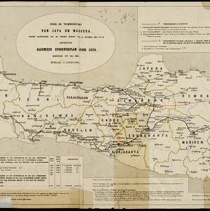
Spoor- en tramwegkaart van Java en Madoera
1894
Indonesia
The railways and tramways of Java and Madoera (Madura) are shown on this late 19th century map, including lines in use, under construction, and being planned. Each line is named, with their route, length, track gauge and construction costs listed.


Topographische kaart van de residentie Preanger regentschappen
1894
Indonesia
The residency of Preanger (Parahyangan), West Java, with plantations (coconut, coffee, tea, cinchona (‘kina’), betel, teakwood, bamboo) and crops (rice, sugarcane, alang-alang). Two inset maps: a triangulation map, and a map of land route distances.


Kaart van Java: Waarop met arceeringen zyn aangeduid de streken waarop het einde van 1891 opnemingen op irrigatie gebied onderhanden warin / Waarop is aangegeven een ontwerp verdeeling in irrigatie afdeelingen
1893
Indonesia
Two maps about irrigation systems on Java. The first shows areas where systems are in place or being created, with their size. The second map shows Java divided into irrigation departments (both on trial and in operation).


Overzichtskaart en bladwijzer van de residentie Kediri
1893
Indonesia
This overview map of the residency of Kediri (East Java, Indonesia) features roads, railways and paths. It is divided into five regencies, which are subdivided into 28 districts, which are numbered and listed. Major settlements are also marked.


Kaart van Nederlandsch-Indie
1893
Brunei, Cambodia, Indonesia, Malaysia, Singapore, Thailand, Vietnam, East Timor, Philippines, Southeast Asia
Shipping routes are the focus of this map of the Dutch East Indies, indicated by red lines labelled with the name of the shipping company and the destinations. Parcel shipping routes are also shown. Inset maps feature railway lines too.
- Filter from 1595 to 1900
- [remove]Java321
- Dutch East Indies204
- Sumatra128
- Borneo115
- Sulawesi104
- Celebes101
- Malay Peninsula94
- Batavia67
- Siam66
- Jakarta65
- Western New Guinea65
- Java Sea59
- more Detailed Location »


