
Search Results
15 Results found


Oost-Indie
c.1867
Brunei, Cambodia, East Timor, Indonesia, Laos, Malaysia, Myanmar, Philippines, Singapore, Southeast Asia, Thailand, Vietnam
Map of the East Indies in the mid-19th century, with Dutch colonial territory (Dutch East Indies) coloured in brown. Dutch administrative regions—such as residencies (‘residentie’) and governorates (‘gouvernement’)—are labelled.

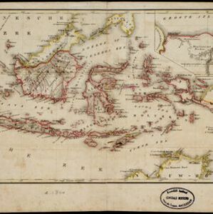
Nederlandsche overzeesche bezittingen / Oost-Indië
1856
Brunei, East Timor, Indonesia, Malaysia, Singapore
Map of the East Indies, showing Dutch colonial territory (Dutch East Indies) in the mid-19th century. Coloured borders are used to highlight internal administrative regions. Three inset maps show other Dutch territories outside Southeast Asia.

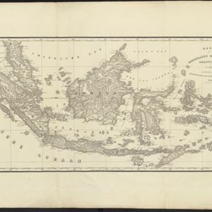
Kaart van Nederlands Oostindische bezittingen
1843
Malaysia, Singapore, Indonesia, East Timor
Map of Dutch colonial possessions in maritime Southeast Asia, labelled with the names of administrative areas. Mountains are represented by hachures, short lines/dashes that give a sense of the shape and steepness of terrain.

Nederlandsch Oost-Indië
1840
Brunei, East Timor, Indonesia, Malaysia, Papua New Guinea, Philippines, Singapore
The Dutch East Indies are bordered in red on this mid-19th century map. A maritime postal route from China to Europe, via Singapore and Penang, is shown. Another maritime route, from Batavia to Singapore, is also marked.
- Filter from 1839 to 1867
- [remove]East Timor15
- Indonesia15
- [remove]Malaysia15
- Singapore15
- Brunei11
- Philippines7
- Thailand6
- Cambodia2
- Laos2
- Myanmar2
- Southeast Asia2
- Vietnam2
- more Simple Location »
- Borneo15
- Celebes15
- Java15
- Malay Peninsula15
- [remove]South China Sea15
- Sulawesi15
- Sumatra15
- Celebes Sea13
- Western New Guinea13
- Dutch East Indies11
- Java Sea11
- Maluku Islands11
- more Detailed Location »
- [remove]Colonial Possessions15
- [remove]District/Administrative Border15
- Civic/Metropolitan Border4
- National Border1


