
Search Results


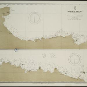
Noordkust Celebes: Hoek Kandi tot hoek Dondo
1899
Indonesia
Two navigation maps for the north coast of Celebes (Sulawesi), featuring bathymetry (sea depth), landmark mountains, reefs and shoals. Obstructions in the water are marked ‘kr’ (coral), ‘m’ (mud), ‘s’ (shells), ‘st’ (stones), and ‘z’ (sand).


Noordkust Celebes: Hoek Samija tot hoek Doelang
1899
Indonesia
A navigation map for the north coast of Celebes (Sulawesi), featuring bathymetry (sea depth), reefs and shoals. Obstructions in the water are marked ‘kr’ (coral), ‘m’ (mud), ‘st’ (stones), and ‘z’ (sand). Five additional maps show details of rivers.


Westkust Celebes: Vaarwaters benoorden Makasser: Blad II
1898
Indonesia
Navigation map of the west coast of Celebes (Sulawesi), north of Makassar. Bathymetry (sea depth), shoals and other obstructions are marked, with hills and settlements as landmarks, and elevations (side views of hills) to aid navigation.

Westkust Celebes: Vaarwaters benoorden Makasser: Blad I
1898
Indonesia
Navigation map of the west coast of Celebes (Sulawesi), north of Makassar. Bathymetry (sea depth), lighthouses, shoals and other obstructions are marked, with trees and hills as landmarks, and elevations (side views of hills) to aid navigation.

Westkust Celebes: Vaarwaters benoorden Makasser: Blad III
1898
Indonesia
Navigation map of the west coast of Celebes (Sulawesi), north of Makassar. Bathymetry (sea depth), shoals and other obstructions are marked, with hills and settlements as landmarks, and elevations (side views of hills) to aid navigation.


