Search

Search Results

Azie

eventc.1900

location_onBrunei, Cambodia, East Timor, Indonesia, Laos, Malaysia, Myanmar, Papua New Guinea, Philippines, Singapore, Southeast Asia, Thailand, Vietnam

Dutch-language map of Asia, with mainland Southeast Asia labelled ‘Achter Indie [Beyond India]’.

Azie

eventc.1900

location_onBrunei, Cambodia, East Timor, Indonesia, Laos, Malaysia, Myanmar, Papua New Guinea, Philippines, Singapore, Southeast Asia, Thailand, Vietnam

Dutch-language map of Asia, with mainland Southeast Asia labelled ‘Achter Indie [Beyond India]’.

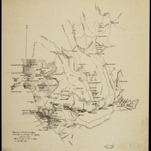
Historische, chronologische overzichtskaart van den Atjeh oorlog

event1898

location_onIndonesia

The Aceh War (1873–1904) between the Sultanate of Aceh and Dutch colonists is highlighted on this map, with areas coloured to show when the Dutch conquered them. Settlements are marked with flags indicating their status; military roads are in red.

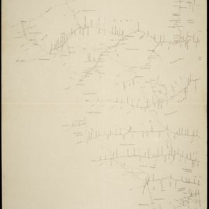
Kaart van de Vallei van Pidië, de Moekim VII en de Vallei van Tangsé

event1899

location_onIndonesia

Large-scale topographic map of the northeast coast of Sumatra around the city of Sigli, Aceh, spread over 16 sheets plus a cover sheet of the whole area. The map focuses on two river valleys, mountains, marshland, villages and rice paddies.

Kaart van Groot Atjeh, 1874-1895

event1899

location_onIndonesia

This map of Groot Atjeh (Aceh, northern Sumatra) focuses on Dutch military posts in and around the city of Kota Radja (Banda Aceh) during the Aceh War. It shows new permanent and temporary posts being added over the period 1874 to 1895.

Zuidelijk gedeelte van de Chineesche zee: Blad I

event1899

location_onMalaysia, Singapore, Indonesia

Navigation map of the southern part of the South China Sea, including the straits of Malacca and Singapore, and the Riau Archipelago. Bathymetry (sea depth), lighthouses, shoals and other obstructions are marked, with hills to use as landmarks.

Zuidelijk gedeelte van Straat Malaka

event1899

location_onIndonesia

Navigation map of the southern part of the Strait of Malacca. Bathymetry (sea depth), lighthouses (in red and yellow), shoals and other obstructions (clay, coral, mud, rocks, shells, stones, sand) are marked, with hills to use as landmarks.

Figuratieve schetskaart van Daja

event1898

location_onIndonesia

This map of Daja on the west coast of Aceh, Sumatra, was based on information from local Acehnese people (‘vervaardigd op inlichtingen van Atjehers’).

Figuratieve schetskaart van de Pedirstreek

event1898

location_onIndonesia

Map of Pedirstreek (Pidie Regency) on the east coast of Aceh, Sumatra, spread over two sheets. It is divided into administrative areas, and features rice paddies, villages, mosques, roads and local fortifications.

Het door Nederland bezette gebied van Groot-Atjeh met de naaste omgeving

event1899

location_onIndonesia

Map focusing on Kota Radja (city of Banda Aceh, Sumatra) during the Aceh War (1873–1904) fought between the Sultanate of Aceh and Dutch colonists. Dutch forts are shown in a zone around the city, and villages are marked in the surrounding country.

Kaart van 't Rijk Djambi

event1898

location_onIndonesia

Hand-drawn map of the Batang Hari River and its tributaries flowing through west from the city of Djambi (Jambi) to the Barisan Mountains. Types of terrain are noted along the route, e.g. ‘laag heuvelachtig boschterrein [low hilly forest terrain]’.

Landbouw-ondernemingen in de afdeelingen Deli, Batoe Bahara en Asahan (Residentie Oostkust van Sumatra)

event1898

location_onIndonesia

On this map of the east coast of northern Sumatra, red borders divide the land into agricultural properties, each with a number to identify it. The whole area is divided into colour-coded administrative districts.

close

  • Filter from 1595 to 1900

Current results range from 1595 to 1900