
Search Results
Filter
Language
Dutch
Remove constraint Language: Dutch
Detailed Location
Sunda Strait
Remove constraint Detailed Location: Sunda Strait
Settlement Features
Kampong/Village
Remove constraint Settlement Features: Kampong/Village
Political Regions
District/Administrative Border
Remove constraint Political Regions: District/Administrative Border
5 Results found


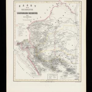
Kaart van de Residentie Lampongsche Districten
1860
Indonesia
Map of the Dutch colonial administrative region (residency) of Lampung at the southern tip of Sumatra, divided into five regencies (yellow borders). (From ‘Algemeene Atlas van Nederlandsche Indie [General Atlas of the Dutch East Indies]’.)
- Filter from 1860 to 1894
- [remove]Dutch5
- [remove]District/Administrative Border5
- Civic/Metropolitan Border2


