Search

Search Results

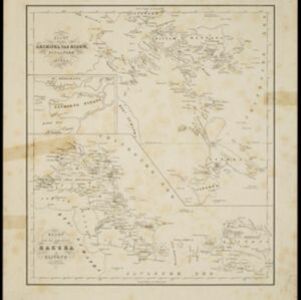
Kaart van den archipel van Riouw, Singapore en Lingga / Kaart van de eilanden Bangka en Blitong

event1857

location_onIndonesia, Singapore

Two maps featuring many of the islands between the Malay Peninsula, Sumatra and Borneo. In the top map, Batam, Bintan, Lingga and many of the smaller Riau Islands. In the bottom map, Bangka and Belitung on the east coast of Sumatra.

Nederlandsche overzeesche bezittingen / Oost-Indië

event1856

location_onBrunei, East Timor, Indonesia, Malaysia, Singapore

Map of the East Indies, showing Dutch colonial territory (Dutch East Indies) in the mid-19th century. Coloured borders are used to highlight internal administrative regions. Three inset maps show other Dutch territories outside Southeast Asia.

Nederlandsch Oost-Indië / Java

eventc.1850

location_onBrunei, East Timor, Indonesia, Malaysia, Philippines, Singapore, Thailand

Two maps of the Dutch East Indies: one of the whole region, and one of Java alone. Both are divided into administrative regions—e.g. Java is divided into regencies—with coloured borders.

Nederlandsche bezittingen buiten Europa

eventc.1850

location_onBrunei, East Timor, Indonesia, Malaysia, Singapore

Map of the East Indies, showing Dutch colonial territory (Dutch East Indies) in the mid-19th century. Three inset maps show other Dutch territories outside Southeast Asia.

Nederlands Oostindische bezittingen, 1848

event1848

location_onBrunei, East Timor, Indonesia, Malaysia, Philippines, Singapore

Map of the Dutch East Indies, with blue borders showing the extent of Dutch colonial territory in 1848. It was published by the North Holland Regional Association of the Dutch Teachers' Association.

Oost Indien

event1845

location_onBrunei, East Timor, Indonesia, Malaysia, Philippines, Singapore

Map of the East Indies in the mid-19th century, with the borders of Dutch colonial territory (Dutch East Indies) marked in brown.

Oost Indien

event1845

location_onBrunei, East Timor, Indonesia, Malaysia, Philippines, Singapore

Map of the East Indies in the mid-19th century, with the borders of Dutch colonial territory (Dutch East Indies) marked in brown.

Nederland en deszelfs koloniën

event1844

location_onBrunei, East Timor, Indonesia, Malaysia, Singapore

Map of the East Indies, with the borders of Dutch colonial territory marked in brown. The Malay Peninsula (‘Malakka’) has green borders, indicating it is a British possession. Four inset maps show other Dutch territories outside Southeast Asia.

close