
Search Results


Schetskaart der afdeeling Westkust van Atjeh
1888
Indonesia
From a Dutch geographical society journal, this map of the west coast of Atjeh (Aceh), Sumatra, shows shoals, reefs, bathymetry (sea depth) and anchor points. On land, there are mountains (with heights), rivers, pepper plantations and rice fields.


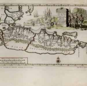
Het Eiland Java: zoo als het sederd de tyden der Portugysen by de Ed. Oost-Indize maatschappye bekend geworden en bevaren is
1714
Indonesia
Published in the early 18th century by the Dutch publisher Pieter van der Aa (1659–1733), this map of Java and the Java Sea is decorated with a colourful painted scene of merchants and boats at a trading port.
'T koninkryk Sunda met dat van Iava by d'Inwoonderen voor een Eiland
1707
Indonesia
Java is shown as two separate islands on this map, with the western island named Sunda. The southern coast is labelled as ‘unknown’. A colourful cartouche is decorated with a painting of indigenous Javanese people meeting and trading with Europeans.
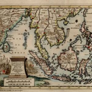
D' Indiaanze landschappen, zeen en eylanden, van Couchin af, tot in de Moluccos, en na by gelegen eylanden
1707
Brunei, Cambodia, East Timor, Indonesia, Laos, Malaysia, Myanmar, Philippines, Vietnam, Thailand, Southeast Asia, Singapore
The title cartouche of this early 18th century map of Southeast Asia is decorated with two drawings of battles. On the left, a sea battle with smoke rising from the ships’ cannons. On the right, an army attacks a walled city which is on fire.


