
Search Results

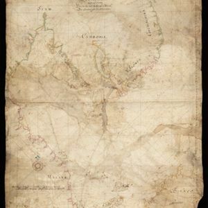
[Portolan chart of the South China Sea]
1679
Malaysia, Brunei, Cambodia, Thailand, Vietnam
A brightly-coloured hand-drawn map of the South China Sea. The compass is at the centre of a rhumbline network, a web of lines to aid navigation. Bathymetry (sea depth), islands, anchor points, shoals and reefs are also marked.

[Zuid-Chinese Zee]
1686
Indonesia, Malaysia, Thailand, Cambodia, Vietnam
Early navigation map of the South China Sea. The web of lines is a rhumbline network, while the numbers indicate sea depth (bathymetry), both used to aid navigation. A route around the Gulf of Thailand is marked with text and the dates 1643 and 1644.

[Dutch portolan chart of the island of Madura]
c.1700
Indonesia
Colourful hand-drawn portolan (nautical) navigation chart, featuring bathymetry (sea depth), shoals and reefs, and anchor points. The coasts have pictorial representations of landmarks (trees, houses, mountains). Orientated with south at the top.

[Dutch Portolan chart of the Java Sea]
c.1700
Indonesia
Hand-drawn portolan (nautical) chart, featuring a rhumbline network (the web of interconnected lines), bathymetry (sea depth), shoals and reefs, elevations (side views of landmark mountains), and names of coastal settlements, all to aid navigation.


De reede en stadt Batavia, is geleegen aan de noord kust van 't eyland Groot Iava inde Oost Indische Zee
1728
Indonesia
A map of the bay of the port city of Batavia (Jakarta). To aid navigation, a rhumbline network (the web of interconnected lines), bathymetry (sea depth), and small islands, shoals and reefs are marked. An inset map shows the city in more detail.

De Straat Sunda in de Oost-Indische Zee tussen de eylanden Sumatra en Iava
1728
Indonesia
Chart of the Sunda Strait, focusing on bays and islands, and showing bathymetry (sea depth), anchor points, shoals and reefs, landmarks, and a rhumbline network, all to aid navigation. Includes an inset map of the bay of the city of Banten on Java.

Deese wassende pas-kaart van Oost-Indien, is nu te bekoomen voor die deselve begeeren
c.1728-1738
Brunei, Cambodia, East Timor, Indonesia, Laos, Malaysia, Myanmar, Papua New Guinea, Philippines, Singapore, Southeast Asia, Thailand, Vietnam
Map of the Indian Ocean dominated by a rhumbline network—a web of interconnected lines used to help plot routes—with a compass rose at the centre. At the top there are (incomplete) drawings of people with text in Dutch, French, English and Spanish.
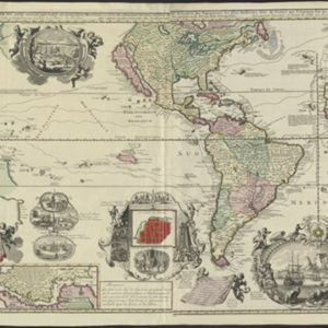
Carte nouvelle de la Mer du Sud
1730
East Timor, Indonesia, Papua New Guinea, Philippines, Vietnam
This elaborately illustrated map of the Atlantic and Pacific Oceans includes the eastern islands of Southeast Asia. The routes of five expeditions west across the Pacific are marked, including that of Ferdinand Magellan to the Philippines in 1520.

De Straat Sunda in de Oost-Indische Zee tussen de Eylanden Sumatra en Java
c.1750
Indonesia
Chart of the Sunda Strait, focusing on bays and islands, and showing bathymetry (sea depth), anchor points, shoals and reefs, landmarks, and a rhumbline network, all to aid navigation. Includes an inset map of the bay of the city of Banten on Java.


