Search

Search Results

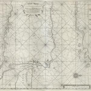
A new and correct chart of part of the island of Java from the west end to Batavia with the Streights of Sunda

event1711

location_onIndonesia

This early 18th century maritime map charts the waters of the Straits of Sunda, between the islands of Java and Sumatra. The web of lines is a rhumbline network, while the numbers indicate sea depth (bathymetry), both used to aid navigation.

A large draught of the east end of Java and Madura shewing the Streights of Bally

event1711

location_onIndonesia

This early 18th century maritime map charts the waters between the islands of Java, Madura and Bally (Bali). The web of lines is a rhumbline network, while the numbers indicate sea depth (bathymetry), both used to aid navigation.

Asia: corrected from the observations communicated to the Royal Society at London and the Royal Academy at Paris

event1708

location_onBrunei, Cambodia, East Timor, Indonesia, Laos, Malaysia, Myanmar, Philippines, Singapore, Southeast Asia, Thailand, Vietnam

An early 18th century map of Asia by the English cartographer John Senex, featuring labels noting details of the inhabitants of some areas e.g. on Borneo: ‘The Middle of this Isle is Inhabited by a People call’d Beaujous Idolaters’.

Asia

event1705

location_onBrunei, Cambodia, East Timor, Indonesia, Laos, Malaysia, Myanmar, Philippines, Singapore, Southeast Asia, Thailand, Vietnam

Map of Asia from the second volume of ‘Navigantium atque itinerantium bibliotheca: or, A compleat collection of voyages and travels: consisting of above four hundred of the most authentick writers’ published by John Harris in 1705.

A mapp of Batavia with all itts forts

event1704

location_onIndonesia

This early 18th century map of Batavia (Jakarta) shows an important port city, with military forts, a long pier, and many ships at sea. However, the map also shows a city surrounded by fields and plantations, for producing crops and grazing animals.

A mapp of the islands before Batavia

event1704

location_onIndonesia

This early 19th century map is from a book titled ‘Mr. John Nieuhoff's Voyages’ in which the author reports on his travels to Southeast Asia, including a detailed description of the important port city of Batavia, as shown on the map.

Present Asia: distinguisht into its general divisions or countries together with their capital cities chief rivers mountains &c.

event1701

location_onBrunei, Cambodia, East Timor, Indonesia, Laos, Malaysia, Myanmar, Papua New Guinea, Philippines, Singapore, Southeast Asia, Thailand, Vietnam

This map of Asia is dedicated to Prince William, Duke of Gloucester, and features a drawing of his coat of arms. He had been in line to succeed to the English throne, but died at the age of 11 in 1700, the year before this map was produced.

A new map of the East Indies: taken from M. de Fer's map of Asia, shewing their cheif divisions, cities, towns, ports, rivers, mountains &c.

event1701

location_onBrunei, Cambodia, East Timor, Indonesia, Laos, Malaysia, Myanmar, Vietnam, Thailand, Southeast Asia, Singapore, Philippines

This early 18th century map shows Southeast Asia alongside India and part of China, with the names of cities, towns, ports, rivers and mountains marked. A handwritten note at the top left comments on the map's accuracy.

[Portolan chart of the Java Sea]

event1701

location_onMalaysia, Indonesia

Hand-drawn portolan (nautical) chart, featuring a rhumbline network (the web of interconnected lines), bathymetry (sea depth), shoals and reefs, and names of coastal settlements, all to aid navigation. With a colourful compass rose.

A new mapp of Asia: divided into kingdoms & provinces

event1690

location_onBrunei, Cambodia, East Timor, Indonesia, Laos, Malaysia, Myanmar, Philippines, Singapore, Southeast Asia, Thailand, Vietnam

A detailed late 17th century map of Asia, showing ancient kingdoms and the place names of important settlements. The cartouche features a drawing of Asian traders selling their goods, while a camel, monkey and two birds look on.

[Chart of the Indian Ocean]

event1684

location_onCambodia, Indonesia, Malaysia, Myanmar, Thailand

Colourful hand-drawn portolan (nautical) navigation chart, featuring a rhumbline network (the web of interconnected lines), islands, shoals and reefs. With an elaborately decorated cartouche, scale and compass roses. Vellum on folding wood boards.

[Chart of the Indian Ocean]

event1682

location_onCambodia, Indonesia, Malaysia, Myanmar, Singapore, Thailand

Colourful hand-drawn portolan (nautical) navigation chart, featuring a rhumbline network (the web of interconnected lines), islands, shoals and reefs. With elaborately decorated scales and compass roses. Mounted on folding wood boards.

close