A chart of the Indian and Pacific Oceans with particular plans of the harbours
event1847
location_onBrunei, Cambodia, East Timor, Indonesia, Laos, Malaysia, Myanmar, Papua New Guinea, Philippines, Southeast Asia, Singapore, Thailand, Vietnam
A new chart of the Straits of Malacca
event1830
location_onMalaysia, Indonesia, Singapore
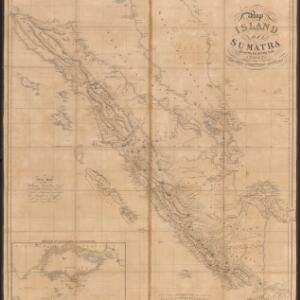
Map of the island of Sumatra constructed chiefly from surveys taken by order of the late Sir Thos. Stamford Raffles
event1829
location_onIndonesia, Malaysia, Singapore
Strait of Malacca: Sheet II
event1823
location_onMalaysia, Singapore, Indonesia
Strait of Malacca: Sheet II
event1823
location_onMalaysia, Singapore, Indonesia
Strait of Malacca: Sheet 1st
event1812
location_onMalaysia, Indonesia
Chart of East Indian Islands exhibiting the several Passages between the Indian and Pacific Oceans
event1800
location_onBrunei, Cambodia, East Timor, Indonesia, Laos, Malaysia, Myanmar, Philippines, Singapore, Southeast Asia, Thailand, Vietnam
[Sumatra and the Strait of Malacca]
eventc.1800
location_onMalaysia, Singapore, Indonesia
The coast of India from Pulo Timon to Pulo Cambir comprehending the Malayan coast, the Gulf of Siam, the coasts of Tsiampa and Cochinchina, with the adjacent islands and part of the isle of Borneo
event1794
location_onThailand, Malaysia, Cambodia, Indonesia, Brunei, Vietnam