
Search Results
Filter
Language
English
Remove constraint Language: English
Detailed Location
Sunda Islands
Remove constraint Detailed Location: Sunda Islands
Detailed Location
Western New Guinea
Remove constraint Detailed Location: Western New Guinea
Collections
Beinecke Rare Book and Manuscript Library Yale University
Remove constraint Collections: Beinecke Rare Book and Manuscript Library Yale University
3 Results found

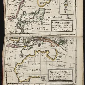
Iapon or Niphon the land of Iesso and Straits of the Vries / New Guinea, New Britain, and New Holland &c.
1732
East Timor, Indonesia, Papua New Guinea
The London-based cartographer Herman Moll (1654?–1732) created this map of New Guinea and the neighbouring islands of maritime Southeast Asia. It shows that in the 1730s, the details of New Guinea and Australia (‘New Holland’) were uncertain.

Asia divided into its principall regions in which may be seen the extent of the Empires, Monarchies, Kingdoms and States which at present divide Asia
1680
Brunei, Cambodia, East Timor, Indonesia, Laos, Malaysia, Myanmar, Papua New Guinea, Philippines, Singapore, Southeast Asia, Thailand, Vietnam
This late 17th century map of Asia is by William Berry, based on an earlier map by the French cartographer Nicolas Sanson. Dedicated to King Charles II, it features the royal coat of arms of the United Kingdom in its elaborate cartouche.
- Borneo3
- Java3
- [remove]Sunda Islands3
- [remove]Western New Guinea3
- Malacca2
- Malay Peninsula2
- Maluku Islands2
- Philippine Islands2
- South China Sea2
- Sulawesi2
- Sumatra2
- Amboina1
- more Detailed Location »


