
Search Results


Military district no. 1: Department of northern Luzon
1900
Philippines
A map of the northwest coastal region of Luzon, Philippines made for the American military during the Philippine–American War (1899–1902). The area is divided into provinces, and major roads, settlements, mountains and rivers are marked.


A sketch map of the East Indian possessions of the Netherlands
1886
Brunei, Indonesia, Malaysia, Papua New Guinea, Philippines, Singapore
Produced by the Intelligence Branch of the British War Office, this map shows Dutch colonial territories in maritime Southeast Asia, and their political and military divisions in Java and Madura. British and Spanish territories are also marked.

Borneo
1851
Malaysia, Southeast Asia, Philippines, East Timor, Vietnam, Brunei, Indonesia
Map of Borneo—with insets of Southeast Asia, Sarawak and Labuan—featuring temperature data, volcanoes, English colonial territory, products of Borneo, geology (rock types), bathymetry (sea depth) and elevations (side views of mountains with heights).

Borneo
1851
Malaysia, Southeast Asia, Philippines, East Timor, Vietnam, Indonesia, Brunei
Map of Borneo—with insets of Southeast Asia, Sarawak and Labuan—featuring temperature data, volcanoes, English colonial territory, products of Borneo, geology (rock types), bathymetry (sea depth) and elevations (side views of mountains with heights).

Eastern islands or Malay archipelago
1836
Brunei, Cambodia, East Timor, Indonesia, Laos, Malaysia, Myanmar, Philippines, Singapore, Southeast Asia, Vietnam, Thailand
Brief notes printed on this 19th century map of Southeast Asia provide details about each region, including: numbers and ethnicity of the population, local or colonial rulers, crops and products, geography (corals, forests, volcanos, earthquakes).
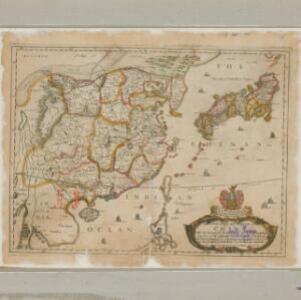
A new mapp of y Empire of China: with its severall provinces or kingdomes, together with the adjacent isles of Japan or Niphon, Formosa, Hainan etc.
1669
Cambodia, Laos, Philippines, Thailand, Vietnam, Myanmar
Although mainly of China and Japan, this map includes some of the northern parts of Southeast Asia. The map is dedicated to Sir Thomas Peyton, an English Member of Parliament who was imprisoned for supporting the king during the English Civil War.
- Filter from 1669 to 1900
- [remove]District/Administrative Border11
- Colonial Possessions4
- Regional Border2
- Civic/Metropolitan Border1
- National Border1


