
Search Results


Map of Singapore and surrounding country
1899
Malaysia, Singapore, Indonesia
Map of Singapore Island, including the surrounding islands and straits, and southern Johor. Lighthouses are marked in red and yellow, including Horsburgh Lighthouse on Pedra Branca, Raffles Lighthouse and Fort Canning Lighthouse.
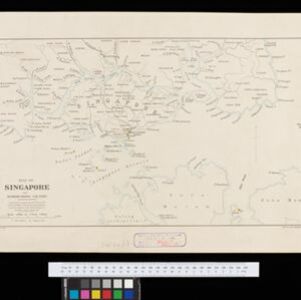
Map of Singapore and surrounding country
1896
Singapore, Malaysia, Indonesia
Map of Singapore Island, including the surrounding islands and straits, and southern Johor. Lighthouses are marked in red and yellow, including Horsburgh Lighthouse on Pedra Branca, Raffles Lighthouse and Fort Canning Lighthouse.
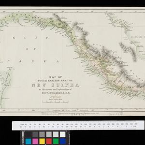
Map of South Eastern part of New Guinea: to illustrate the explorations of Rev. J. Chalmers, L.M.S.
1887
Papua New Guinea
Map of the southeast coast of British New Guinea, divided into administrative regions, with the northern regions left mostly blank. Based on the explorations of the Scottish missionary James Chalmers.


Map of Burmah, and adjacent countries
1875
Myanmar, Thailand
Small notes on this map of Burmah (Myanmar) describe mines, crops and products produced, names of local tribes etc. e.g.: ‘a passage to Rangoon in the wet season’, ‘Ship of 400 tons built here’, ‘Alompra’s birth place’, ‘Gold dust in the streams’.

Principal Dutch colonies in the Indian seas
1872
Brunei, Indonesia, Malaysia
Two maps of the Dutch East Indies, decorated with drawings of local people and animals. Dutch colonial territory and local sultanates and provinces are highlighted. The heights of Java’s mountains and settlements are displayed in an elevation view.

Map of Prince of Wales' Island or Pulo Penang and province Wellesley
1853
Malaysia
Map of the Penang Strait, including written instructions on how to navigate the strait. On land, areas of cultivation are marked, with a table listing acreage used for each crop. A boundary with Siam based on an 1831 treaty is also shown.

Borneo
1851
Malaysia, Southeast Asia, Philippines, East Timor, Vietnam, Brunei, Indonesia
Map of Borneo—with insets of Southeast Asia, Sarawak and Labuan—featuring temperature data, volcanoes, English colonial territory, products of Borneo, geology (rock types), bathymetry (sea depth) and elevations (side views of mountains with heights).

Borneo
1851
Malaysia, Southeast Asia, Philippines, East Timor, Vietnam, Indonesia, Brunei
Map of Borneo—with insets of Southeast Asia, Sarawak and Labuan—featuring temperature data, volcanoes, English colonial territory, products of Borneo, geology (rock types), bathymetry (sea depth) and elevations (side views of mountains with heights).

Eastern islands or Malay archipelago
1836
Brunei, Cambodia, East Timor, Indonesia, Laos, Malaysia, Myanmar, Philippines, Singapore, Southeast Asia, Vietnam, Thailand
Brief notes printed on this 19th century map of Southeast Asia provide details about each region, including: numbers and ethnicity of the population, local or colonial rulers, crops and products, geography (corals, forests, volcanos, earthquakes).
- Filter from 1817 to 1900
- [remove]District/Administrative Border14
- Colonial Possessions7
- Civic/Metropolitan Border2
- National Border2
- Regional Border1


