
Search Results


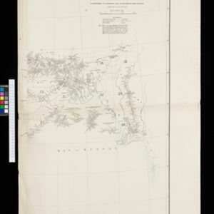
Portion of coal fields tract: Upper Chindwin district
1892
Myanmar
A map surveying coal fields close to the Chindwin River in Upper Burma (Myanmar). Mountains are shown by using hachures: short lines/dashes that give a sense of the shape and steepness of terrain. Survey stations are marked with their height.

Map to accompany preliminary report on the Chin-Lushai Country
1892
Myanmar
Topographical map of the mountainous border region between India and northwest Burma (Myanmar), showing rivers, lakes, villages, towns, roads and railways. High points are marked with their heights so they can be used for triangulation.

Sketch map of the head of Collingwood Bay
1892
Papua New Guinea
Map of Collingwood Bay, north coast of New Guinea, with bearings to mountains, bathymetry (sea depth), shoals and reefs. On land, notes on terrain (‘sloping plains’, ‘Stiff clay soil’), vegetation (‘Casuarina trees’) and people (‘FRIENDLY TRIBE’).

Sketch map shewing the rivers and an outline of the coast... Gulf of Papua, British New Guinea
1892
Papua New Guinea
Map of part of the west coast of the Gulf of Papua, with islands, river mouths, shoals, bathymetry (water depth), notes to aid navigation. On land, notes on terrain (‘Limestone Hill’), vegetation (‘Pandanus & Nipa Palms’) and people (‘Paia Tribe’).

Map of British New Guinea
1892
Papua New Guinea, Indonesia
Map of British New Guinea, focusing on the sea (islands, shoals, reefs), coast (settlements, bays), mountains and land (‘dense forest’, ‘timbered with Eucalyptus’). Inset maps of Port Moresby, Samarai Island, and the whole island of New Guinea.


New sketch map of the protected Malay State of Perak
1892
Malaysia
Map of state of Perak (Malay Peninsula) with a table of statistics: area, population, road/railway/river lengths, revenue, tin exports. Straits Settlements highlighted red. Someone has added handwritten travel times/distances by steamer/road/train.

Stanford's Library Map of Asia
1891
Brunei, Cambodia, East Timor, Indonesia, Laos, Malaysia, Myanmar, Philippines, Singapore, Southeast Asia, Thailand, Vietnam
Southeast Asia is on sheet four of this map. British colonial territory—British Burma, the Straits Settlements, Sarawak, British North Borneo—is highlighted in red, with the Dutch East Indies, Spanish Philippines and Portuguese East Timor also shown.

Map to illustrate the operations about Sadon, Upper Burma
1891
Myanmar
Map of northeast Burma (Myanmar) bordering China's Yunnan Province. The title refers to ‘operations’ around the town of Sadon, possibly part of the Burmese resistance movement against British colonial rule in the late 19th century.
- Filter from 1598 to 1900
- Myanmar248
- Indonesia228
- Malaysia220
- Thailand213
- Singapore185
- Vietnam179
- Cambodia171
- Laos163
- Philippines156
- Brunei150
- East Timor132
- Southeast Asia130
- more Simple Location »


