
Search Results
18 Results found


Carte des courants généraux dans l'Océan Indien
c.1849-1863
Brunei, Cambodia, East Timor, Indonesia, Laos, Malaysia, Myanmar, Philippines, Singapore, Southeast Asia, Thailand, Vietnam
Map of the Indian Ocean showing the currents (represented by arrows), including during the North East and North West monsoons. Numbers on the arrows indicate the current’s speed.
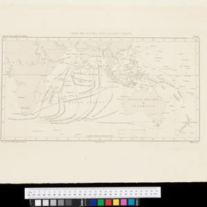
Carte des Routes dans l'Océan Indien
c.1849-1863
Brunei, Cambodia, East Timor, Indonesia, Laos, Malaysia, Myanmar, Papua New Guinea, Philippines, Singapore, Southeast Asia, Thailand, Vietnam
Map of the Indian Ocean showing maritime routes, including some to and around Southeast Asia, where they pass through the Strait of Malacca, the Sunda Strait, and the straits between the Lesser Sunda Islands.

Carte générale de l'Océan Pacifique
1845
Brunei, Cambodia, East Timor, Indonesia, Laos, Malaysia, Myanmar, Papua New Guinea, Philippines, Singapore, Southeast Asia, Thailand, Vietnam
Marine chart of the Pacific Ocean, including Southeast Asia. Small islands, shoals and reefs are marked, and often named, around the seas and straits of the region.

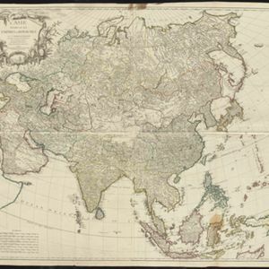
Kaart van Azië ten gebruike der scholen van het Koninkrijk der Nederlanden = Carte d'Asie, a l'usage des maisons d'éducation
1830
Brunei, Cambodia, East Timor, Indonesia, Laos, Malaysia, Myanmar, Philippines, Singapore, Southeast Asia, Thailand, Vietnam
Map of Asia spread over nine sheets, for use in schools. Place names are not printed on the map itself, but are represented by initials and numbers (presumably, there is a legend that lists the names, but it is not present).
L'Asie divisée en ses Empires et Royaumes
1778
Brunei, Cambodia, East Timor, Indonesia, Laos, Malaysia, Myanmar, Philippines, Singapore, Southeast Asia, Thailand, Vietnam
This map shows the empires and kingdoms of Southeast Asia. Its decorative cartouche features drawings of plants, a camel, a vase, and the heads of children blowing to represent wind. An inset shows tall buildings, possibly Asian temples.

Seconde partie de la carte d'Asie: contenant la Chine et partie de la Tartarie, l'Inde au delà du Gange, les isles Sumatra, Java, Borneo, Moluques, Philippines et du Japon
1752
Brunei, Cambodia, East Timor, Indonesia, Laos, Malaysia, Myanmar, Vietnam, Thailand, Southeast Asia, Singapore, Philippines
Labels on this mid-18th century map of Southeast Asia describe various local peoples as ‘sauvage [savage]’, including the ‘Ke-Moy’ of the mountains along the border of Cochinchine (Vietnam) and Camboja (Cambodia), and the ‘Biayos’ of central Borneo.

Seconde partie de la carte d'Asie: contenant la Chine et partie de la Tartarie, l'Inde au delà du Gange, les isles Sumatra, Java, Borneo, Moluques, Philippines et du Japon
1752
Vietnam, Myanmar, Malaysia, Philippines, Singapore, Southeast Asia, Thailand, Laos, Indonesia, East Timor, Cambodia, Brunei
Labels on this mid-18th century map of Southeast Asia describe various local peoples as ‘sauvage [savage]’, including the ‘Ke-Moy’ of the mountains along the border of Cochinchine (Vietnam) and Camboja (Cambodia), and the ‘Biayos’ of central Borneo.

Seconde partie de la carte d'Asie: contenant la Chine et partie de la Tartarie, l'Inde au delà du Gange, les isles Sumatra, Java, Borneo, Moluques, Philippines et du Japon
1752
Brunei, Cambodia, East Timor, Indonesia, Laos, Malaysia, Myanmar, Vietnam, Thailand, Southeast Asia, Singapore, Philippines
Labels on this mid-18th century map of Southeast Asia describe various local peoples as ‘sauvage [savage]’, including the ‘Ke-Moy’ of the mountains along the border of Cochinchine (Vietnam) and Camboja (Cambodia), and the ‘Biayos’ of central Borneo.

Seconde partie de la carte d'Asie: contenant la Chine et partie de la Tartarie, l'Inde au delà du Gange, les isles Sumatra, Java, Borneo, Moluques, Philippines et du Japon
1752
Brunei, Cambodia, East Timor, Indonesia, Laos, Malaysia, Myanmar, Vietnam, Thailand, Southeast Asia, Singapore, Philippines
Labels on this map describe various local peoples as ‘sauvage [savage]’, including the ‘Ke-Moy’ of the mountains along the border of Cochinchine (Vietnam) and Camboja (Cambodia), and the ‘Biayos’ of central Borneo. Top half of map is missing.
- Filter from 1713 to 1889
- Brunei18
- [remove]Cambodia18
- East Timor18
- Indonesia18
- [remove]Laos18
- Malaysia18
- Myanmar18
- Philippines18
- Singapore18
- Southeast Asia18
- Thailand18
- [remove]Vietnam18
- more Simple Location »
- Borneo18
- [remove]Celebes18
- Java18
- [remove]Malay Peninsula18
- [remove]Sulawesi18
- Sumatra18
- Sunda Islands14
- Maluku Islands13
- Western New Guinea13
- Isles de la Sonde10
- Royaume de Siam10
- Isles Moluques9
- more Detailed Location »


