
Search Results
11 Results found


Mer des Indes: cartes de la direction et de l'intensité probables des vents
1880
Brunei, Cambodia, Indonesia, Malaysia, Myanmar, Philippines, Thailand, Vietnam, Singapore
A series of four maps of the Indian Ocean—one for each quarter of the calendar year—showing the direction and intensity of the winds, including around the seas of Southeast Asia. There are extensive explanatory notes.

Kaart van Azië ten gebruike der scholen van het Koninkrijk der Nederlanden = Carte d'Asie, a l'usage des maisons d'éducation
1830
Brunei, Cambodia, East Timor, Indonesia, Laos, Malaysia, Myanmar, Philippines, Singapore, Southeast Asia, Thailand, Vietnam
Map of Asia spread over nine sheets, for use in schools. Place names are not printed on the map itself, but are represented by initials and numbers (presumably, there is a legend that lists the names, but it is not present).

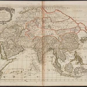
L'Asie Dressée Selon les Observations de Mrs. De l' Academie Royale des Sciences
1749
Brunei, Cambodia, East Timor, Indonesia, Laos, Malaysia, Myanmar, Singapore, Philippines, Southeast Asia, Thailand, Vietnam
Map of Asia based on observations of members of the French Academy of Sciences. Its decorative cartouche features a drawing of a censer (incense burner).

Deese wassende pas-kaart van Oost-Indien, is nu te bekoomen voor die deselve begeeren
c.1728-1738
Brunei, Cambodia, East Timor, Indonesia, Laos, Malaysia, Myanmar, Papua New Guinea, Philippines, Singapore, Southeast Asia, Thailand, Vietnam
Map of the Indian Ocean dominated by a rhumbline network—a web of interconnected lines used to help plot routes—with a compass rose at the centre. At the top there are (incomplete) drawings of people with text in Dutch, French, English and Spanish.
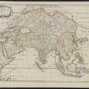
L'Asie
1669
Brunei, Cambodia, East Timor, Indonesia, Laos, Malaysia, Myanmar, Philippines, Singapore, Southeast Asia, Thailand, Vietnam
Produced by the French cartographer Nicolas Sanson (1600–1667) in the mid-17th century, this map of Asia features hand-coloured regional borders. Its cartouche features cherubim and decorative scrollwork.
Asie
1650
Brunei, Cambodia, East Timor, Indonesia, Laos, Malaysia, Myanmar, Philippines, Singapore, Southeast Asia, Thailand, Vietnam
Produced by the French cartographer Nicolas Sanson (1600–1667) in the mid-17th century, this map of Asia features hand-coloured regional borders. Its cartouche features decorative scrollwork, fabric and tassels.

Asie
1650
Brunei, Cambodia, East Timor, Indonesia, Laos, Malaysia, Myanmar, Philippines, Singapore, Southeast Asia, Thailand, Vietnam
A mid-17th century map of Asia, showing mainland Southeast Asia divided into regions such as Cochinchine, Chiampa and Tunquin (Vietnam), Sian (Thailand), Pegu, Martaban and Arracan (Myanmar), and Camboge (Cambodia).
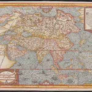
Asie
1575
Brunei, Cambodia, East Timor, Indonesia, Laos, Malaysia, Myanmar, Philippines, Singapore, Southeast Asia, Thailand, Vietnam
A colourful 16th century map by André Thevet, with illustrations of ships and sea monsters around the seas of Southeast Asia. The map's scale is decorated with cartography tools such as rulers and a compass.
- Filter from 1575 to 1889
- [remove]Brunei11
- Cambodia11
- Indonesia11
- [remove]Malaysia11
- Myanmar11
- Philippines11
- Singapore11
- Thailand11
- Vietnam11
- East Timor10
- Laos10
- Southeast Asia10
- more Simple Location »


