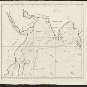
Carte du Détroit de la Sonde, depuis la pointe de Winerou jusques à l'Isle du Nord
c.1790
Indonesia
Navigation chart of the Sunda Strait, focusing on bays and islands, and showing bathymetry (sea depth), anchor points, shoals and reefs. Includes an inset map of the bay of the Isle de Mew (Peucang Island). The web of lines is a rhumbline network.