
Search Results


Carte des Isles de la Sonde et du Détroit de Malaca
1791
Brunei, Indonesia, Malaysia, Singapore
Map based on the expeditions of Jean-François de Surville, a merchant captain with the French East India Company. Some details are from the diary of the French Navy officer Théobald René, Comte de Kergariou-Locmaria, who explored the region in 1785.

Carte du Détroit de la Sonde, depuis la pointe de Winerou jusques à l'Isle du Nord
c.1790
Indonesia
Navigation chart of the Sunda Strait, focusing on bays and islands, and showing bathymetry (sea depth), anchor points, shoals and reefs. Includes an inset map of the bay of the Isle de Mew (Peucang Island). The web of lines is a rhumbline network.
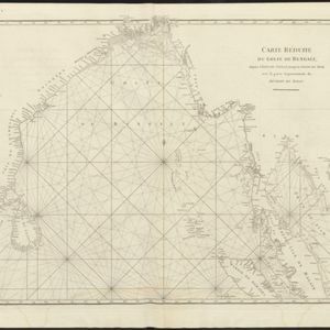
Carte réduite du Golfe de Bengale, depuis l'isle de Ceylan jusqu'au Golfe de Siam, avec la partie septentrionale du détroit de Malac
1775
Myanmar, Thailand, Cambodia, Malaysia, Indonesia
Map of the Bay of Bengal, with the western coast of mainland Southeast Asia. Shoals, reefs and islands are marked. The web of lines is a rhumbline network, while the numbers indicate sea depth (bathymetry), both used to aid navigation.
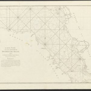
Carte Plate de la Partie Septentrionale du Détroit de Malac: depuis la Rade D'Áchem jusqu'a Malac
1775
Indonesia, Malaysia
Map of the northern Malacca Strait—between Sumatra and Malaya—with shoals and reefs marked, some labelled as ‘dangerous’. The web of lines is a rhumbline network, while the numbers indicate sea depth (bathymetry), both used to aid navigation.
Carte réduite du Golfe de Bengale, depuis l'isle de Ceylan jusqu'au Golfe de Siam, avec la partie septentrionale du détroit de Malac
1775
Myanmar, Thailand, Cambodia, Malaysia, Indonesia
Map of the Bay of Bengal, with the western coast of mainland Southeast Asia. Shoals, reefs and islands are marked. The web of lines is a rhumbline network, while the numbers indicate sea depth (bathymetry), both used to aid navigation.
Carte Plate de la Partie Septentrionale du Détroit de Malac: depuis la Rade D'Áchem jusqu'a Malac
1775
Indonesia, Malaysia
Map of the northern Malacca Strait—between Sumatra and Malaya—with shoals and reefs marked, some labelled as ‘dangerous’. The web of lines is a rhumbline network, while the numbers indicate sea depth (bathymetry), both used to aid navigation.

Carte de l'Isle de Java, avec les isles de Banca, de Billiton, et une partie de celles de Sumatra et de Borneo
1775
Indonesia
This 18th century maritime navigation map charts the waters between the islands of Java, Sumatra and Borneo. A route south towards the Sunda Strait, as taken by the French ship Mascarin in March and April 1772, is highlighted.


