
Search Results
84 Results found


Carte des courants généraux dans l'Océan Indien
c.1849-1863
Brunei, Cambodia, East Timor, Indonesia, Laos, Malaysia, Myanmar, Philippines, Singapore, Southeast Asia, Thailand, Vietnam
Map of the Indian Ocean showing the currents (represented by arrows), including during the North East and North West monsoons. Numbers on the arrows indicate the current’s speed.

Carte des Routes dans l'Océan Indien
c.1849-1863
Brunei, Cambodia, East Timor, Indonesia, Laos, Malaysia, Myanmar, Papua New Guinea, Philippines, Singapore, Southeast Asia, Thailand, Vietnam
Map of the Indian Ocean showing maritime routes, including some to and around Southeast Asia, where they pass through the Strait of Malacca, the Sunda Strait, and the straits between the Lesser Sunda Islands.

Carte générale de l'Océan Pacifique
1845
Brunei, Cambodia, East Timor, Indonesia, Laos, Malaysia, Myanmar, Papua New Guinea, Philippines, Singapore, Southeast Asia, Thailand, Vietnam
Marine chart of the Pacific Ocean, including Southeast Asia. Small islands, shoals and reefs are marked, and often named, around the seas and straits of the region.

Carte generale de l'Asie: où se trouvent les découvertes faites par Bougainville, Dampier et La Pérouse
1833
Brunei, Cambodia, East Timor, Indonesia, Laos, Malaysia, Myanmar, Papua New Guinea, Philippines, Singapore, Southeast Asia, Thailand, Vietnam
This map of Asia is marked with the routes taken through Southeast Asia by the British Royal Navy captain James Cook, and the French explorer Lapérouse. The title also refers to two other explorers: Louis Antoine de Bougainville and William Dampier.

Kaart van Azië ten gebruike der scholen van het Koninkrijk der Nederlanden = Carte d'Asie, a l'usage des maisons d'éducation
1830
Brunei, Cambodia, East Timor, Indonesia, Laos, Malaysia, Myanmar, Philippines, Singapore, Southeast Asia, Thailand, Vietnam
Map of Asia spread over nine sheets, for use in schools. Place names are not printed on the map itself, but are represented by initials and numbers (presumably, there is a legend that lists the names, but it is not present).

Asie
c.1790
Brunei, East Timor, Cambodia, Indonesia, Laos, Malaysia, Myanmar, Philippines, Singapore, Southeast Asia, Thailand, Vietnam
This map of Asia features four different scales: French, Russian, Turkish and Chinese. Each country had their own measuring system, so this was not uncommon at the time.

Les Indes orientales et leur archipel
1785
Brunei, Cambodia, East Timor, Indonesia, Laos, Malaysia, Myanmar, Philippines, Singapore, Southeast Asia, Thailand, Vietnam
A piece of paper printed with a list of the various regions of Asia, including the regions of Southeast Asia, has been adhered to the right-hand side of this late 18th century map of Asia.
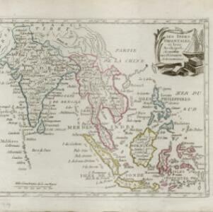
Les Indes orientales et leur archipel: assujetties aux observations astronomiques
1784
Brunei, Cambodia, East Timor, Indonesia, Laos, Malaysia, Myanmar, Philippines, Singapore, Southeast Asia, Thailand, Vietnam
This map of Asia has coloured borders around mainland Southeast Asia, the Philippines, the Sunda Islands (‘Isles de la Sonde’) and the Maluku Islands (‘Isles Moluques’). The cartouche features a drawing of a sailing ship and boxes of goods.
- Filter from 1643 to 1889
- Brunei84
- [remove]Cambodia84
- [remove]East Timor84
- Indonesia84
- Malaysia84
- Philippines84
- [remove]Singapore84
- Southeast Asia84
- Thailand84
- Vietnam84
- Laos77
- Myanmar77
- more Simple Location »


