Search

Search Results

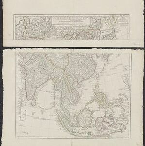
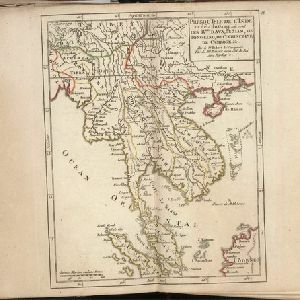
Presqu'Isle de l'Inde au dela du Gange, ou sont les Rmes. d'Ava, de Siam, de Tong-King, de Cochinchine, de Camboge &c.

eventc.1770-1779

location_onBrunei, Cambodia, Indonesia, Laos, Malaysia, Myanmar, Singapore, Thailand, Vietnam

On this late 18th century map, the modern nation states of mainland Southeast Asia can be seen emerging: Myanmar (here labelled Ava), Laos, Vietnam (Tong-King and Cochinchine), Cambodia (Camboge), Thailand (Siam) and Malaysia (Malaca).

Archipel des Indes Orientales: qui comprend les Isles de la Sonde, Moluques et Philippines

eventc.1757-1786

location_onBrunei, Cambodia, East Timor, Indonesia, Malaysia, Philippines, Singapore, Thailand, Vietnam, Southeast Asia

This 18th century map of Southeast Asia by the French cartographer Gilles Robert de Vaugondy features the national borders of the Philippines in green, and of modern Indonesia in yellow. The Malay Peninsula and modern Cambodia and Vietnam are in red.

Seconde partie de la carte d'Asie: contenant la Chine et partie de la Tartarie, l'Inde au delà du Gange, les isles Sumatra, Java, Borneo, Moluques, Philippines et du Japon

event1752

location_onBrunei, Cambodia, East Timor, Indonesia, Laos, Malaysia, Myanmar, Vietnam, Thailand, Southeast Asia, Singapore, Philippines

Labels on this mid-18th century map of Southeast Asia describe various local peoples as ‘sauvage [savage]’, including the ‘Ke-Moy’ of the mountains along the border of Cochinchine (Vietnam) and Camboja (Cambodia), and the ‘Biayos’ of central Borneo.

Archipel des Indes Orientales: qui comprend les Isles de la Sonde, Moluques et Philippines

event1750

location_onBrunei, Cambodia, East Timor, Indonesia, Malaysia, Philippines, Singapore, Southeast Asia, Thailand, Vietnam

This 18th century map of Southeast Asia by the French cartographer Gilles Robert de Vaugondy features the national borders of the Philippines in green, and of modern Indonesia in yellow. The Malay Peninsula and modern Cambodia and Vietnam are in red.

Carte des Indes Orientalis

event1748

location_onBrunei, Cambodia, East Timor, Indonesia, Laos, Malaysia, Myanmar, Philippines, Singapore, Southeast Asia, Vietnam, Thailand

This mid-18th century map features labels noting the local populations, including the Kemois of the mountains and deserts of Cochinchinae (Vietnam) and the Byayos of Borneo. The map’s cartouche is embellished with maritime and military paraphernalia.

Carte des Indes Orientales: 2de. feuille

event1748

location_onBrunei, East Timor, Indonesia, Malaysia, Philippines, Vietnam

This map features a label noting that the Byayos people inhabited the mountains of central Borneo. Another note at the northeast tip of Borneo states that the location and number of islands in the area is uncertain. Sheet two of two.

Carte d'Asie: dressée sur les memoires envoyéz par le Czar a l'Academie Royale des Science

event1745

location_onBrunei, Cambodia, East Timor, Indonesia, Laos, Malaysia, Myanmar, Philippines, Singapore, Southeast Asia, Thailand, Vietnam

An early 18th century map of Asia by the French cartographer Guillaume Delisle (1675–1726). Regions are indicated with coloured borders, and the southern part of Borneo is labelled ‘Côte de Mahometans [Coast of the Muslims]’.

Asia secundum legitimas projectionis stereographicae regulas et juxta recentissimas observation et relationes = Carte de l'Asie, projettée stereographiquement, tirée des relations et observations

event1744

location_onBrunei, Cambodia, East Timor, Indonesia, Laos, Malaysia, Myanmar, Philippines, Singapore, Southeast Asia, Thailand, Vietnam

This mid-18th century map of Asia has a stereographic projection to aid in navigation. There is also an illustration featuring two Asian men depicted as native warriors, with a robed woman, as well as a large lizard.

Carte d'Asie: dressée sur les memoires envoyéz par le Czar a l'Academie Royale des Science

event1723

location_onBrunei, Cambodia, East Timor, Indonesia, Laos, Malaysia, Myanmar, Singapore, Philippines, Southeast Asia, Thailand, Vietnam

An early 18th century map of Asia by the French cartographer Guillaume Delisle (1675–1726). Regions are indicated with coloured borders, and the southern part of Borneo is labelled ‘Côte de Mahometans [Coast of the Muslims]’.

Carte des Indes et de la Chine

event1705

location_onBrunei, Cambodia, East Timor, Indonesia, Laos, Malaysia, Myanmar, Philippines, Southeast Asia, Singapore, Thailand, Vietnam

An early 18th century map of Asia by the French cartographer Guillaume Delisle (1675–1726). Regions are indicated with coloured borders, and the southern part of Borneo is labelled ‘Côte de Mahometans [Coast of the Muslims]’.

Partie de la nouvelle Grande Cartes des Indes Orientales, contenant les Isles Maldives, Ceylan, Malacca, Sumatra &c.

event1700

location_onIndonesia, Malaysia, Singapore, Thailand

Sumatra and the Malay Peninsula feature on this map of the Indian Ocean. Enganno Island, west of southern Sumatra, has a label that translates as ‘inhabited by very pernicious savages’. An inset map depicts the Madura Strait between Java and Madura.

Description de la coste septentrionale de Noua Guinea

event1618

location_onIndonesia

The north coast of New Guinea is mapped here as it was discovered by the Dutch explorer Willem Corneliszoon Schouten. He is named on the map as Guillaume Schouten de Hoorn, known as the first to sail from Europe to the Pacific Ocean via Cape Horn.

close

  • Filter from 1618 to 1770

Current results range from 1618 to 1770