
Search Results
193 Results found


Malacca
1616
Brunei, Cambodia, Indonesia, Laos, Malaysia, Myanmar, Singapore, Thailand, Vietnam
French text on the back of this map of mainland Southeast Asia describes the kingdom of Pegu (Myanmar), its royal palace, ports and trade with Sumatra and Malacca (rice, butter, oil, salt, onions, silver, porcelain, quicksilver, copper, pewter etc.).

Description de la coste septentrionale de Noua Guinea
1618
Indonesia
The north coast of New Guinea is mapped here as it was discovered by the Dutch explorer Willem Corneliszoon Schouten. He is named on the map as Guillaume Schouten de Hoorn, known as the first to sail from Europe to the Pacific Ocean via Cape Horn.

Indes orientalles ou du Gange
1643
Brunei, Cambodia, Indonesia, Laos, Malaysia, Myanmar, Philippines, Thailand, Vietnam
Four long rivers flow south through mainland Southeast Asia on this map: the ‘Menan’, ‘Manthabam’ and ‘Cosmin’ originate at a mythical lake (‘Chiamai Lac’) in southern China, while the ‘Mecon’ (Mekong) flows from the hills of Cochinchina (Vietnam).
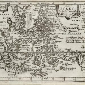
Les isles des Indes orientalles
1643
Brunei, Cambodia, East Timor, Indonesia, Laos, Malaysia, Myanmar, Philippines, Singapore, Southeast Asia, Thailand, Vietnam
French text on the right of this map notes that the ‘Molucques’—an important region for the spice trade—were near the island of Gilolo (modern Halmahera) and names them as Ternate, Tindor (Tidore), Mutir (Moti), Machiam (Makian) and Bachian (Bacan).

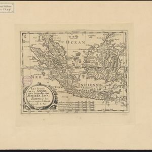
Les Isles de la Sonde: entre lesquelles sont Sumatra, Java, Borneo &c.
1652
Brunei, Indonesia, Malaysia, Singapore
This mid-17th century map of the Sunda Isles (‘Isles de la Sonde’) includes the Malay Peninsula in addition to Sumatra, Java and Borneo. Mountain ranges and jungles are shown pictorially, and the islands and coasts feature shoals and reefs.
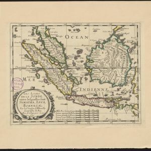
Les Isles de la Sonde: entre lesquelles sont Sumatra, Java, Borneo &c.
c.1652
Brunei, Indonesia, Malaysia, Singapore
This mid-17th century map of the Sunda Isles (‘Isles de la Sonde’) includes the Malay Peninsula in addition to Sumatra, Java and Borneo. Mountain ranges and jungles are shown pictorially, and the islands and coasts feature shoals and reefs.

- Filter from 1602 to 1889
- Indonesia170
- Malaysia147
- Singapore127
- Thailand124
- Vietnam124
- Brunei123
- Cambodia121
- Philippines114
- Myanmar109
- Laos98
- East Timor97
- Southeast Asia86
- more Simple Location »


