
Search Results
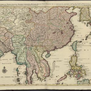
La nouvelle grande carte des Indes Orientales
1792
Cambodia, Laos, Myanmar, Philippines, Thailand, Vietnam
Map of mainland Southeast Asia divided into kingdoms. Larger settlements are marked pictorially with a red building symbol. The desert of Cochinchine (Vietnam) is labelled as being inhabited by the ‘Kemoys Peuples Barbares [Kemoys Barbarian People]’.

Carte des Isles de la Sonde et du Détroit de Malaca
1791
Brunei, Indonesia, Malaysia, Singapore
Map based on the expeditions of Jean-François de Surville, a merchant captain with the French East India Company. Some details are from the diary of the French Navy officer Théobald René, Comte de Kergariou-Locmaria, who explored the region in 1785.

Asie
c.1790
Brunei, East Timor, Cambodia, Indonesia, Laos, Malaysia, Myanmar, Philippines, Singapore, Southeast Asia, Thailand, Vietnam
This map of Asia features four different scales: French, Russian, Turkish and Chinese. Each country had their own measuring system, so this was not uncommon at the time.

Carte du Détroit de la Sonde, depuis la pointe de Winerou jusques à l'Isle du Nord
c.1790
Indonesia
Navigation chart of the Sunda Strait, focusing on bays and islands, and showing bathymetry (sea depth), anchor points, shoals and reefs. Includes an inset map of the bay of the Isle de Mew (Peucang Island). The web of lines is a rhumbline network.
Asie
c.1790
Brunei, East Timor, Cambodia, Indonesia, Laos, Malaysia, Myanmar, Philippines, Singapore, Southeast Asia, Thailand, Vietnam
This map of Asia features four different scales: French, Russian, Turkish and Chinese. Each country had their own measuring system, so this was not uncommon at the time.
Carte du Détroit de la Sonde, depuis la pointe de Winerou jusques à l'Isle du Nord
c.1790
Indonesia
Navigation chart of the Sunda Strait, focusing on bays and islands, and showing bathymetry (sea depth), anchor points, shoals and reefs. Includes an inset map of the bay of the Isle de Mew (Peucang Island). The web of lines is a rhumbline network.
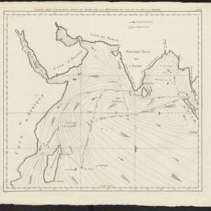
Carte des courants pour le tems de la Mousson du S.O., au N. de la ligne
c.1780
Malaysia, Indonesia, Myanmar, Thailand
Map of the Indian Ocean showing the currents (represented by arrows) and winds (represented with letters A to F) during the monsoon seasons. Three routes—one old and two new—from the Isle de France (Mauritius) east to the Strait of Malacca are shown.
- Indonesia142
- Malaysia134
- Thailand118
- Vietnam112
- Myanmar110
- Singapore110
- Brunei108
- Cambodia106
- Philippines101
- East Timor91
- Laos90
- Southeast Asia79
- more Simple Location »


