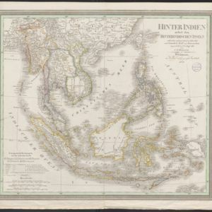
Search

Search Results

Asien

eventc.1840

location_onBrunei, Cambodia, Indonesia, Laos, Malaysia, Myanmar, Papua New Guinea, Philippines, Singapore, Southeast Asia, Thailand, Vietnam

On this map of Asia, colours are used to show the colonial territories of the European powers: cities in the Philippines are underlined in blue, indicating they are Spanish; the Dutch East Indies are in yellow (Dutch); and Singapore is red (British).

Hinter Indien nebst den Hinterindischen Inseln

event1836

location_onCambodia, East Timor, Indonesia, Laos, Malaysia, Myanmar, Brunei, Philippines, Singapore, Southeast Asia, Thailand, Vietnam

Coloured borders identify the colonial possessions of Britain, the Netherlands, Spain, Denmark and Portugal in mid-19th century Southeast Asia. Cities are marked with symbols indicating population, and military forts are marked with star symbols.

Hinter Indien nebst den Hinterindischen Inseln

event1836

location_onBrunei, Cambodia, East Timor, Indonesia, Laos, Malaysia, Myanmar, Philippines, Singapore, Southeast Asia, Thailand, Vietnam

Coloured borders identify the colonial possessions of Britain, the Netherlands, Spain, Denmark and Portugal in mid-19th century Southeast Asia. Cities are marked with symbols indicating population, and military forts are marked with star symbols.

Reduzirte Karte vom Sunda- oder Borneo-Meere

event1835

location_onIndonesia, Malaysia

A navigation map of the Java Sea and Sunda Islands, with bathymetry (sea depth), maritime routes, shoals and reefs, and elevations (side views of terrestrial landmarks). Inset maps feature the bay at Batavia and the straits between the Sunda Islands.

Ost-Indien mit den Inseln

eventc.1835

location_onBrunei, Cambodia, East Timor, Indonesia, Laos, Malaysia, Myanmar, Philippines, Singapore, Southeast Asia, Thailand, Vietnam

On this map of India and Southeast Asia, borders are outlined and cities underlined in different colours to show the colonial territories of the European powers. On Borneo, the names of indigenous peoples are listed (‘Dayak’s, Papua’s, Bugi’s’).

Reduzirte Karte vom Sunda- oder Borneo-Meere

event1835

location_onMalaysia, Indonesia

A navigation map of the Java Sea and Sunda Islands, with bathymetry (sea depth), maritime routes, shoals and reefs, and elevations (side views of terrestrial landmarks). Inset maps feature the bay at Batavia and the straits between the Sunda Islands.

Ost-Indien mit den Inseln

eventc.1835

location_onBrunei, Cambodia, East Timor, Indonesia, Laos, Malaysia, Myanmar, Philippines, Singapore, Southeast Asia, Thailand, Vietnam

On this map of India and Southeast Asia, borders are outlined and cities underlined in different colours to show the colonial territories of the European powers. On Borneo, the names of indigenous peoples are listed (‘Dayak’s, Papua’s, Bugi’s’).

Reduzirte Karte vom Sunda- oder Borneo-Meere

event1835

location_onMalaysia, Indonesia

A navigation map of the Java Sea and Sunda Islands, with bathymetry (sea depth), maritime routes, shoals and reefs, and elevations (side views of terrestrial landmarks). Inset maps feature the bay at Batavia and the straits between the Sunda Islands.

Asien 1831

event1831

location_onBrunei, Cambodia, East Timor, Indonesia, Laos, Malaysia, Myanmar, Papua New Guinea, Philippines, Singapore, Southeast Asia, Thailand, Vietnam

On this map of Asia, borders are outlined and cities underlined in different colours to show the colonial territories of the European powers: Russian, British, Dutch, French, Spanish, Portuguese and Danish.

Ost-Indien mit den Inseln

event1831

location_onBrunei, Cambodia, East Timor, Indonesia, Laos, Malaysia, Myanmar, Philippines, Singapore, Southeast Asia, Thailand, Vietnam

On this map of India and Southeast Asia, borders are outlined and cities underlined in different colours to show the colonial territories of the European powers: British, Dutch, Spanish, Portuguese, French and Danish.

Asien 1831

event1831

location_onBrunei, Cambodia, East Timor, Indonesia, Laos, Malaysia, Myanmar, Papua New Guinea, Philippines, Singapore, Southeast Asia, Thailand, Vietnam

On this map of Asia, borders are outlined and cities underlined in different colours to show the colonial territories of the European powers: Russian, British, Dutch, French, Spanish, Portuguese and Danish.

close