
Search Results


Ostindische Inseln
c.1870
Brunei, Cambodia, East Timor, Indonesia, Laos, Malaysia, Myanmar, Philippines, Singapore, Southeast Asia, Thailand, Vietnam
On this map of Southeast Asia, borders are outlined and cities underlined in different colours to show the colonial territories of the European powers. On Borneo, the names of indigenous peoples are listed (‘Dayak’s, Papua’s, Bugi’s’).

Asien
1850
Brunei, Cambodia, East Timor, Indonesia, Laos, Malaysia, Myanmar, Singapore, Philippines, Southeast Asia, Thailand, Vietnam
This map of Asia uses hachures—short lines/dashes that give a sense of the shape and steepness of terrain—over most of Southeast Asia. Major rivers, islands and cities are also marked.

Ost-Indien mit den Inseln
1850
Brunei, Cambodia, East Timor, Indonesia, Laos, Malaysia, Myanmar, Singapore, Philippines, Southeast Asia, Thailand, Vietnam
On this map of India and Southeast Asia, borders are outlined and cities underlined in different colours to show the colonial territories of the European powers: British, Dutch, Spanish, Portuguese, French and Danish.
Asien
1850
Brunei, Cambodia, East Timor, Indonesia, Laos, Malaysia, Myanmar, Singapore, Philippines, Southeast Asia, Thailand, Vietnam
This map of Asia uses hachures—short lines/dashes that give a sense of the shape and steepness of terrain—over most of Southeast Asia. Major rivers, islands and cities are also marked.
Ost-Indien mit den Inseln
1850
Brunei, Cambodia, East Timor, Indonesia, Laos, Malaysia, Myanmar, Singapore, Philippines, Southeast Asia, Thailand, Vietnam
On this map of India and Southeast Asia, borders are outlined and cities underlined in different colours to show the colonial territories of the European powers: British, Dutch, Spanish, Portuguese, French and Danish.
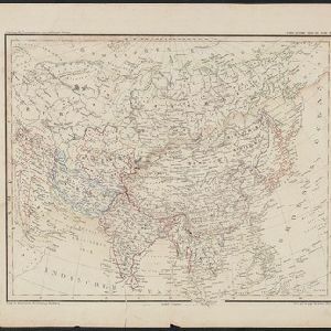
Übersichtskarte der Asiatischen Staaten
1845
Brunei, Cambodia, Indonesia, Laos, Malaysia, Myanmar, Philippines, Singapore, Southeast Asia, Thailand, Vietnam
This map of Asia is from the mid-19th century ‘Grosser Atlas der Erde [Great Atlas of the Earth]’ by the German publisher Albrecht Platt. It shows part of Southeast Asia, including the region’s borders with India and China.

Asien
c.1840
Brunei, Cambodia, Indonesia, Laos, Malaysia, Myanmar, Papua New Guinea, Philippines, Singapore, Southeast Asia, Thailand, Vietnam
On this map of Asia, colours are used to show the colonial territories of the European powers: cities in the Philippines are underlined in blue, indicating they are Spanish; the Dutch East Indies are in yellow (Dutch); and Singapore is red (British).
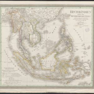
Hinter Indien nebst den Hinterindischen Inseln
1836
Cambodia, East Timor, Indonesia, Laos, Malaysia, Myanmar, Brunei, Philippines, Singapore, Southeast Asia, Thailand, Vietnam
Coloured borders identify the colonial possessions of Britain, the Netherlands, Spain, Denmark and Portugal in mid-19th century Southeast Asia. Cities are marked with symbols indicating population, and military forts are marked with star symbols.
- Filter from 1600 to 1890
- [remove]German27
- Borneo27
- [remove]Siam27
- [remove]Sulawesi27
- Sumatra27
- Celebes25
- Java24
- Malay Peninsula23
- South China Sea22
- Maluku Islands20
- Western New Guinea19
- Birma18
- Neu Guinea18
- more Detailed Location »
- River20


