Search

Search Results

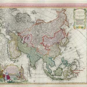
Carte des Indes Orientales

event1748

location_onBrunei, Cambodia, East Timor, Indonesia, Laos, Malaysia, Myanmar, Philippines, Singapore, Southeast Asia, Thailand, Vietnam

This mid-18th century map features a label noting that the Byayos people inhabited the mountains of central Borneo. Another note at the northeast tip of Borneo states that the location and number of islands in the area is uncertain.

Asia secundum legitimas projectionis stereographicae regulas et juxta recentissimas observation et relationes = Carte de l'Asie, projettée stereographiquement, tirée des relations et observations

event1744

location_onBrunei, Cambodia, East Timor, Indonesia, Laos, Malaysia, Myanmar, Philippines, Singapore, Southeast Asia, Thailand, Vietnam

This mid-18th century map of Asia has a stereographic projection to aid in navigation. There is also an illustration featuring two Asian men depicted as warriors, with a robed woman, as well as a large lizard.

Asiae recentissima delineatio, qua Status et Imperia totius Orientis unacum Orientalibus Indiis exhibentur

event1730

location_onVietnam, Myanmar, Papua New Guinea, Philippines, Singapore, Southeast Asia, Thailand, Malaysia, Laos, Indonesia, East Timor, Cambodia, Brunei

This map's cartouche features an illustration of three men bowing before a ruler on a throne. There is also what was probably meant to be a lion, though the poor likeness suggests it was based on written descriptions rather than real life experience.

Molvccae insvlae celeberrimae

eventc.1730-1778

location_onIndonesia

A map of a small island chain off the west coast of the island of Gilolo (modern Halmahera in the Maluku Islands of Indonesia). The military forts and ships were used by the European colonial powers during conflicts over the area’s spice trade.

Asiae recentissima delineatio, qua Status et Imperia totius Orientis unacum Orientalibus Indiis exhibentur

event1716

location_onVietnam, Myanmar, Papua New Guinea, Philippines, Singapore, Southeast Asia, Thailand, Malaysia, Laos, Indonesia, East Timor, Cambodia, Brunei

This map's cartouche features an illustration of three men bowing before an enthroned ruler. A second image is of a procession where a horned four-armed humanoid creature is being carried on poles by two bearers, while musicians follow behind.

India orientalis

event1713

location_onBrunei, Cambodia, East Timor, Indonesia, Laos, Malaysia, Myanmar, Philippines, Singapore, Southeast Asia, Thailand, Vietnam

This map is from ‘Universus terrarum orbis scriptorum calamo delineatus’ by Alphonsus Lasor a Varea (pseudonym of Raffaello Savonarola (1680–1748), a monk who worked in the monastery library in Padua).

Insulæ Indiæ orientalis

event1690

location_onBrunei, Cambodia, East Timor, Indonesia, Laos, Malaysia, Myanmar, Philippines, Singapore, Southeast Asia, Thailand, Vietnam

The southern coast of Java ('Iava Maior') on this map is represented by a dotted line, indicating that the exact coastline was unknown at this time. Italian text on the reverse describes the Maluku Islands including Ambon, Banda and Ternate.

Insvlarvm Bandanensivm: novißima delineatio

eventc.1680-1709

location_onIndonesia

A navigation map of the Banda Islands marked with bathymetry (sea depth), shoals and anchor points. On the island of Goenonghapy (Banda Api), a volcano erupts (‘api’ means ‘fire’ in Indonesian), and there is a military fort (‘Campa Nga’) on Nera.

Insularum Moluccarum nova descriptio

eventc.1641-1651

location_onIndonesia

A mid-17th century map by the Dutch cartographer Jan Jansson, depicting a small chain of six islands off the west coast of Gilolo (modern Halmahera, in the Indonesian Maluku Islands). German text on the reverse describes the Maluku Islands.

Molvccae insvlae celeberrimae

eventc.1640-1655

location_onIndonesia

This small island chain off the west coast of Gilolo (Halmahera in the Maluku Islands, Indonesia), was an important area for the spice trade. Latin text on the reverse describes the trade/islands. North is located to the right, rather than the top.

Ins: Macjan, Ins: Bactjan

eventc.1631-1657

location_onIndonesia

These pages are probably from ‘Newe Welt und Americanische Historien’ by Johann Gottfried. There are maps of Pulau Makian (‘Ins. Macjan’) and Pulau Bacan (Ins. Bacjan) in the Maluku Islands, and a plan of a fort on Makian.

Insulæ Indiæ orientalis

event1630

location_onBrunei, Cambodia, East Timor, Indonesia, Laos, Malaysia, Myanmar, Philippines, Singapore, Southeast Asia, Thailand, Vietnam

The southern coast of Java ('Iava Maior') on this map is represented by a dotted line, indicating that the exact coastline was unknown at this time. French text on the reverse describes the geography, crops, animals etc. of the Maluku Islands.

close

  • Filter from 1540 to 1748

Current results range from 1540 to 1748