
Search Results


Asiæ in tabula geographica delineatio
1720
Brunei, Cambodia, Indonesia, East Timor, Malaysia, Myanmar, Philippines, Singapore, Laos, Southeast Asia, Thailand, Vietnam, Papua New Guinea
This colourful early 18th century map shows Asia along with part of Europe and Africa. It is decorated with a painting of Asian traders negotiating over a sale of carpets, while three lions, a ship and city walls complete the picture.

Orientaliora Indiarum Orientalium cum insulis adjacentibus à promontorio C. Comorin ad Iapan = Pascaert van t'Ooster gedeelte van Oost Indien van C. Comorin tot Iapan
1715
Brunei, Cambodia, East Timor, Indonesia, Laos, Malaysia, Myanmar, Philippines, Singapore, Southeast Asia, Thailand, Vietnam
The cartouche on this early 18th century navigation map features the title in Latin and Dutch, as well as a wealth of detailed drawings illustrating the region’s trade: Asian merchants, their goods and animals, and two female European customers.


Exactissima Asiae delineatio, in praecipuas regiones, ceterasq partes divisa
1705
Brunei, Cambodia, East Timor, Indonesia, Laos, Myanmar, Malaysia, Philippines, Singapore, Southeast Asia, Thailand, Vietnam
The illustration on this map highlights the wealth of the Asian trade routes, with merchants wearing colourful and elaborate robes presenting valuable treasures to a royal figure. A monkey, tortoise and camel emphasise the 'exoticism' of Asia.

Nova tabvla India Orientalis
c.1702-1705
Brunei, Cambodia, East Timor, Indonesia, Laos, Malaysia, Myanmar, Philippines, Singapore, Southeast Asia, Thailand, Vietnam
An early 18th century map of the Indian Ocean, illustrated with a drawing of Asian merchants riding an elephant and using a camel to transport their goods. Other men use bows and arrows to hunt ostriches. Ships are also shown sailing on the ocean.
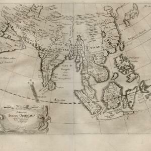
Delineatio Indiæ orientalis: quae lumen dabit huic itinerario et historiis
1700
Brunei, Cambodia, Indonesia, Laos, Malaysia, Myanmar, Philippines, Singapore, Southeast Asia, Thailand, Vietnam
This map of India and Southeast Asia—or ‘Indiae Orientalis [East Indies]’ as it was called at the time—was published in a book documenting the travels of the German scholar and geographer Adam Olearius (1599–1671).

Indiae orientalis, nec non insularum adiacentium
1698
Myanmar, Philippines, Singapore, Southeast Asia, Thailand, Vietnam, Malaysia, Laos, Indonesia, East Timor, Cambodia, Brunei
The cartouche on this map of Asia is decorated with a colourful painting illustrating the region’s commerce, with Asian merchants displaying an assortment of goods, including jewellery, porcelain vessels and figurines, textiles and exotic animals.

Indiæ Orientalis nec non Insularum Adiacentium Nova Descriptio
1689
Brunei, Cambodia, East Timor, Indonesia, Laos, Malaysia, Myanmar, Philippines, Singapore, Southeast Asia, Thailand, Vietnam
The cartouche on this map of Asia is decorated with a colourful depiction of a European man negotiating with an Asian merchant to buy an assortment of Asian goods, including jewellery, porcelain vessels and figurines, and textiles.

Accuratissima totius Asiæ tabula: In omnes partes divisa
c.1689-1702
Brunei, Cambodia, East Timor, Indonesia, Laos, Malaysia, Myanmar, Philippines, Singapore, Southeast Asia, Thailand, Vietnam
A detailed late 17th century map of Asia, showing ancient kingdoms and the place names of important settlements. The cartouche features a drawing of Asian traders selling their goods, while a camel, monkey and two birds look on.


