
Search Results
7 Results found


Bowles's new one-sheet map of Asia, divided into its empires, kingdoms, states, and other subdivisions
1795
Brunei, Cambodia, East Timor, Indonesia, Laos, Malaysia, Myanmar, Papua New Guinea, Philippines, Singapore, Southeast Asia, Thailand, Vietnam
A late 18th century map of Asia published in London by John Bowles, with regions indicated by colour. Central Borneo is labelled ‘Part inhabited by the Biayos’, which is seen on many contemporary maps, often with the comment ‘a savage people’.

Asie divisée en ses principaux Etats, Empires & Royaumes
1791
Brunei, Cambodia, East Timor, Indonesia, Laos, Malaysia, Myanmar, Philippines, Singapore, Southeast Asia, Thailand, Vietnam
A late 18th century map of Asia, with notes on the principal states, empires and kingdoms of Asia written in French on the right-hand side.
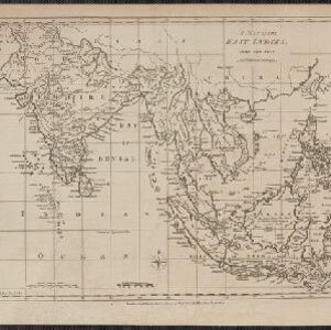
A map of the East Indies
1780
East Timor, Southeast Asia, Brunei, Cambodia, Indonesia, Laos, Malaysia, Myanmar, Philippines, Thailand, Vietnam, Singapore
A 19th century map concentrating on Southeast Asia and India. The island of Borneo is annotated with the text 'The Inland Part of this Island is inhabited by the Biayos a savage People'.
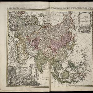
Asia secundum legitimas projectionis stereographicae regulas et juxta recentissimas observation et relationes = Carte de l'Asie, projettée stereographiquement, tirée des relations et observations
1744
Brunei, Cambodia, East Timor, Indonesia, Malaysia, Laos, Myanmar, Philippines, Singapore, Southeast Asia, Thailand, Vietnam
This mid-18th century map of Asia has a stereographic projection to aid navigation. An illustration features Asian men—probably merchants, one of whom sits on a throne—and a kneeling elephant.
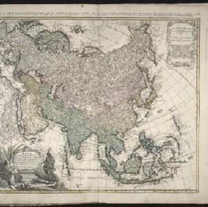
Asia secundum legitimas projectionis stereographicae regulas et juxta recentissimas observation et relationes = Carte de l'Asie, projettée stereographiquement, tirée des relations et observations
1744
Brunei, Cambodia, East Timor, Indonesia, Laos, Malaysia, Myanmar, Philippines, Singapore, Southeast Asia, Thailand, Vietnam
This mid-18th century map of Asia has a stereographic projection to aid in navigation. There is also an illustration featuring two Asian men depicted as native warriors, with a robed woman, as well as a large lizard.

Asia: corrected from the observations communicated to the Royal Society at London and the Royal Academy at Paris
1708
Brunei, Cambodia, East Timor, Indonesia, Laos, Malaysia, Myanmar, Philippines, Singapore, Southeast Asia, Thailand, Vietnam
An early 18th century map of Asia by the English cartographer John Senex, featuring labels noting details of the inhabitants of some areas e.g. on Borneo: ‘The Middle of this Isle is Inhabited by a People call’d Beaujous Idolaters’.


