
Search Results


Straat Riouw: Trigonometrisch opgenomen door het Engelsche opnemings vaartuig
1894
Indonesia
Navigation map of the Riau Strait between Batam, Bintan and Rempang (Riau Archipelago). Bathymetry (sea depth), lighthouses, bouys, currents and obstructions are marked. There are side views of islands and mountains (elevations) to use as landmarks.

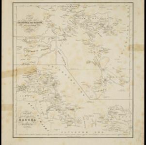
Kaart van de Residentie Riouw en Onderhoorigheden
1860
Indonesia, Singapore, Malaysia
Map of the Dutch colonial administrative region (residency) of Riouw (Riau) focusing on the islands and sea passages, with bathymetry (sea depth) marked. (From ‘Algemeene Atlas van Nederlandsche Indie [General Atlas of the Dutch East Indies]’.)
Kaart van den archipel van Riouw, Singapore en Lingga / Kaart van de eilanden Bangka en Blitong
1857
Indonesia, Singapore
Two maps featuring many of the islands between the Malay Peninsula, Sumatra and Borneo. In the top map, Batam, Bintan, Lingga and many of the smaller Riau Islands. In the bottom map, Bangka and Belitung on the east coast of Sumatra.
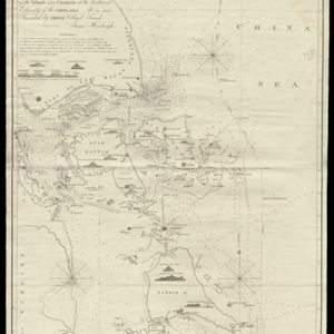
To James Carnegy and Robert Scott Esqrs. of Prince of Wales Island... this Chart of the Islands and Channels at the Southwest Extremity of the China Sea
1824
Malaysia, Singapore, Indonesia
Chart of the Singapore Strait, Riau Archipelago and Lingga Islands, marked with bathymetry (sea depth), side views of landmark mountains (elevations), written notes, and islands, shoals and reefs, all to aid navigation.


