
Search Results
81 Results found


Bowles's new one-sheet map of Asia, divided into its empires, kingdoms, states, and other subdivisions
1795
Brunei, Cambodia, East Timor, Indonesia, Laos, Malaysia, Myanmar, Papua New Guinea, Philippines, Singapore, Southeast Asia, Thailand, Vietnam
A late 18th century map of Asia published in London by John Bowles, with regions indicated by colour. Central Borneo is labelled ‘Part inhabited by the Biayos’, which is seen on many contemporary maps, often with the comment ‘a savage people’.
Asia / engraved for Walkers Geography &c.
1792
Brunei, Cambodia, East Timor, Indonesia, Laos, Malaysia, Myanmar, Papua New Guinea, Philippines, Singapore, Southeast Asia, Thailand, Vietnam
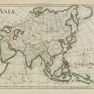
Hand-drawn coloured borders have been added to this map to distinguish various regions: mainland Southeast Asia and most of the islands of maritime Southeast Asia are bordered in green, with Borneo and the Philippines in red.

An Accurate Map of Asia
1783
Brunei, Cambodia, East Timor, Indonesia, Laos, Malaysia, Myanmar, Philippines, Singapore, Southeast Asia, Thailand, Vietnam
From the first volume of John Seally’s ‘A Complete Geographical Dictionary’, this map of Asia includes the ancient kingdoms of mainland Southeast Asia, and the Sunda and Molucca islands (‘Molucca or Spice Islands’) of maritime Southeast Asia.

A map of the East Indies, from the best authorities
1780
Brunei, Cambodia, East Timor, Indonesia, Laos, Malaysia, Myanmar, Philippines, Singapore, Southeast Asia, Thailand, Vietnam
On this map of Asia, Borneo is labelled ‘The Inland Part of this Island is inhabited by the Biayos a savage People’, a description seen on many contemporary maps. The ancient kingdoms of mainland Southeast Asia are also shown.

A New & Accurate Map of Asia
1777
Brunei, Cambodia, East Timor, Indonesia, Laos, Malaysia, Myanmar, Papua New Guinea, Philippines, Singapore, Southeast Asia, Thailand, Vietnam
Created for Middleton’s ‘Complete System of Geography’, this map of Asia includes the ancient kingdoms of mainland Southeast Asia, the Sunda Islands and Moluccas of maritime Southeast Asia, as well as the Philippines and New Guinea.

Nieuwe en naukeurige kaart van Asia
1773
Indonesia, Brunei, Cambodia, East Timor, Laos, Malaysia, Myanmar, Papua New Guinea, Philippines, Singapore, Southeast Asia, Thailand, Vietnam
Map of Asia featuring an early—and very vague—depiction of New Britain (‘Nieuw Brittanje’) which was named by the British explorer William Dampier when he visited in 1700. The ‘Straat van Dampier’ is also shown, dividing New Britain from New Guinea.

East Indies
1769
Brunei, Cambodia, East Timor, Indonesia, Laos, Malaysia, Myanmar, Philippines, Singapore, Southeast Asia, Thailand, Vietnam
Longitude is indicated in two different ways on this mid-18th century map: along the top border, it is shown in degrees (number of degrees east of London); more unusually, along the bottom border, it is shown in time (number of hours east of London).

Archipel des Indes Orientales: qui comprend les Isles de la Sonde, Moluques et Philippines
c.1757-1786
Brunei, Cambodia, East Timor, Indonesia, Malaysia, Philippines, Singapore, Thailand, Vietnam, Southeast Asia
This 18th century map of Southeast Asia by the French cartographer Gilles Robert de Vaugondy features the national borders of the Philippines in green, and of modern Indonesia in yellow. The Malay Peninsula and modern Cambodia and Vietnam are in red.

Archipel des Indes Orientales: qui comprend les Isles de la Sonde, Moluques et Philippines
1750
Brunei, Cambodia, East Timor, Indonesia, Malaysia, Philippines, Singapore, Southeast Asia, Thailand, Vietnam
This 18th century map of Southeast Asia by the French cartographer Gilles Robert de Vaugondy features the national borders of the Philippines in green, and of modern Indonesia in yellow. The Malay Peninsula and modern Cambodia and Vietnam are in red.
- Filter from 1595 to 1870
- [remove]Borneo81
- [remove]Malacca81
- [remove]Siam81
- Sumatra81
- Java71
- Sulawesi66
- Malay Peninsula64
- Celebes63
- Pegu54
- Western New Guinea41
- Iava29
- South China Sea28
- more Detailed Location »


