
Search Results


Asien
1850
Brunei, Cambodia, East Timor, Indonesia, Laos, Malaysia, Myanmar, Singapore, Philippines, Southeast Asia, Thailand, Vietnam
This map of Asia uses hachures—short lines/dashes that give a sense of the shape and steepness of terrain—over most of Southeast Asia. Major rivers, islands and cities are also marked.
Ost-Indien mit den Inseln
1850
Brunei, Cambodia, East Timor, Indonesia, Laos, Malaysia, Myanmar, Singapore, Philippines, Southeast Asia, Thailand, Vietnam
On this map of India and Southeast Asia, borders are outlined and cities underlined in different colours to show the colonial territories of the European powers: British, Dutch, Spanish, Portuguese, French and Danish.

Carte des Routes dans l'Océan Indien
c.1849-1863
Brunei, Cambodia, East Timor, Indonesia, Laos, Malaysia, Myanmar, Papua New Guinea, Philippines, Singapore, Southeast Asia, Thailand, Vietnam
Map of the Indian Ocean showing maritime routes, including some to and around Southeast Asia, where they pass through the Strait of Malacca, the Sunda Strait, and the straits between the Lesser Sunda Islands.

The phenomena of volcanic action: showing the regions visited by earthquakes and the distribution of volcanoes over the globe
1849
Brunei, Cambodia, East Timor, Indonesia, Laos, Malaysia, Myanmar, Papua New Guinea, Philippines, Singapore, Southeast Asia, Thailand, Vietnam
On the main map, the volcanic regions of Southeast Asia are labelled, active and extinct volcanos are marked, and the 1815 eruption of Tumbora (Mount Tambora on Sumbawa) is highlighted. Even more details are shown on an inset map of Southeast Asia.
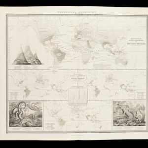
Zoological Geography: Sheet No. 5
1849
Brunei, Cambodia, East Timor, Indonesia, Laos, Malaysia, Myanmar, Papua New Guinea, Philippines, Singapore, Southeast Asia, Thailand, Vietnam
Four world maps showing the distribution of reptiles and snakes, including in Southeast Asia. Lines show the geographical range of individual species, alongside illustrations of some of the animals featured.

The phenomena of volcanic action: showing the regions visited by earthquakes and the distribution of volcanoes over the globe
1849
Brunei, Cambodia, East Timor, Indonesia, Laos, Malaysia, Myanmar, Papua New Guinea, Philippines, Singapore, Southeast Asia, Thailand, Vietnam
On the main map, the volcanic regions of Southeast Asia are labelled, active and extinct volcanos are marked, and the 1815 eruption of Tumbora (Mount Tambora on Sumbawa) is highlighted. Even more details are shown on an inset map of Southeast Asia.

Nederlands Oostindische bezittingen, 1848
1848
Brunei, East Timor, Indonesia, Malaysia, Philippines, Singapore
Map of the Dutch East Indies, with blue borders showing the extent of Dutch colonial territory in 1848. It was published by the North Holland Regional Association of the Dutch Teachers' Association.

Carte générale des possessions néerlandaises aux Indes orientales
1846
Brunei, East Timor, Indonesia, Malaysia, Philippines, Singapore
Map of the Asian colonial possessions of the Netherlands (Dutch East Indies), with an inset of the heights of some of the region’s mountains. A note describes the average temperature, barometer reading and magnetic declination in Batavia at the time.

Die Ostindischen Inseln
1846
Brunei, Cambodia, East Timor, Indonesia, Laos, Malaysia, Myanmar, Philippines, Singapore, Southeast Asia, Thailand, Vietnam
Map of Southeast Asia highlighting the colonial possessions of the Netherlands (Dutch East Indies), Spain (Philippines), Britain (Straits Settlements, Burma, part of Borneo) and Portugal (East Timor). From the German atlas ‘Stielers Handatlas’.
- Filter from 1540 to 1900
- Indonesia315
- Malaysia308
- East Timor306
- Brunei304
- Singapore302
- Philippines301
- Vietnam277
- Thailand276
- Cambodia274
- Southeast Asia271
- Laos265
- Myanmar263
- more Simple Location »
- [remove]Borneo315
- [remove]Maluku Islands315
- Sumatra303
- Java297
- Sulawesi276
- Malay Peninsula233
- Celebes218
- Western New Guinea207
- Sunda Islands188
- Siam123
- South China Sea109
- Malacca94
- more Detailed Location »


