Search

Search Results

Trade Routes in the Far East

event1894

location_onBrunei, Cambodia, Indonesia, Laos, Malaysia, Myanmar, Philippines, Singapore, Thailand, Vietnam

Map of stream ship trade routes around Southeast Asia. Rivers, railways, submarine telegraph cables, lighthouses (fixed, revolving and flashing), graving docks and coaling stations are marked. An inset map shows a railway route from Britain to Asia.

Kaart van Nederlandsch-Indie

event1893

location_onBrunei, Cambodia, Indonesia, Malaysia, Singapore, Thailand, Vietnam, East Timor, Philippines, Southeast Asia

Shipping routes are the focus of this map of the Dutch East Indies, indicated by red lines labelled with the name of the shipping company and the destinations. Parcel shipping routes are also shown. Inset maps feature railway lines too.

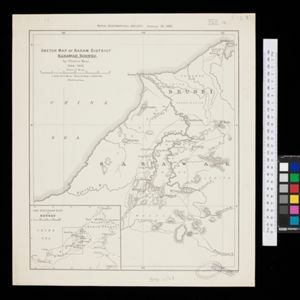
Sketch map of Baram District, Sarawak, Borneo

event1893

location_onMalaysia, Indonesia, Brunei

Map of the Baram District, Borneo, by the British ethnologist Charles Hose, divided into territories of indigenous peoples: Malanaus, Kayans, Kenniahs, Orang-Bukits, Sibops, Madangs, Kalabits, Balaits, Tutongs, Kadayans and Malays.

Stanford's Library Map of Asia

event1891

location_onBrunei, Cambodia, East Timor, Indonesia, Laos, Malaysia, Myanmar, Philippines, Singapore, Southeast Asia, Thailand, Vietnam

Southeast Asia is on sheet four of this map. British colonial territory—British Burma, the Straits Settlements, Sarawak, British North Borneo—is highlighted in red, with the Dutch East Indies, Spanish Philippines and Portuguese East Timor also shown.

Kaart van den Indischen-Archipel, Aanwijzende de standplaatsen der Europeesche ambtenaren bij het Binnenlansch Bestuur

event1891

location_onIndonesia

This map of the Dutch East Indies uses colour to demarcate government administrative areas (residencies or provinces), with red dots/flags indicating the locations of various levels of government officials. With inset maps of west Sumatra and Java.

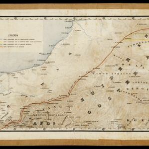
Kaart van een gedeelte van Borneo: met aanwijzing van de grens tusschen het Nederlandsch gebied en dat van het Britsche Protectoraat

event1891

location_onIndonesia, Malaysia, Myanmar

Map marking the border (in orange) agreed between British and Dutch territory on Borneo in 1891. Alternative borders are shown: according to the Dutch (blue), according to the British North Borneo Society (yellow) and proposed by the British (green).

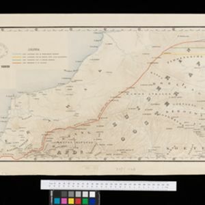
Kaart van een gedeelte van Borneo: met aanwijzing van de grens tusschen het Nederlandsch gebied en dat van het Britsche Protectoraat

event1891

location_onIndonesia, Malaysia

Map marking the border (in orange) agreed between British and Dutch territory on Borneo in 1891. Alternative borders are shown: according to the Dutch (blue), according to the British North Borneo Society (yellow) and proposed by the British (green).

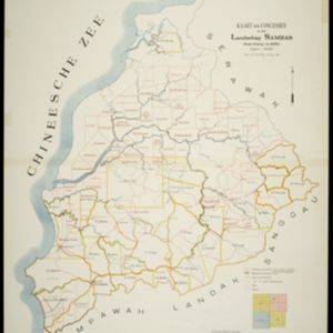
Kaart der Concessiën in het Landschap Sambas (Wester-Afdeeling van Borneo)

event1890

location_onIndonesia

Map of the Sambas Regency on the west coast of Borneo, divided into parcels of land which are labelled with the names of businesses that have been issued with concessions: yellow borders denote agricultural concessions; red are mining concessions.

Kaart van den Nederlandsch-Indischen Archipel

event1890

location_onIndonesia, East Timor, Brunei, Cambodia, Malaysia, Philippines, Singapore, Southeast Asia, Thailand, Vietnam

The seas of the Dutch East Indies are the focus of this map, with maritime routes, sea temperature, sea depth, currents and monsoons shown. There are graphs of population by ethnicity, agriculture and livestock, trade and shipping, and trade exports.

Asia

eventc.1890

location_onBrunei, Cambodia, East Timor, Indonesia, Laos, Malaysia, Myanmar, Philippines, Singapore, Southeast Asia, Thailand, Vietnam

This map of Asia is from ‘Stieler’s Schul-Atlas’, a version of ‘Stielers Handatlas’ that was used widely in German schools in the 19th century.

Asia

eventc.1890

location_onBrunei, Cambodia, East Timor, Indonesia, Laos, Malaysia, Myanmar, Philippines, Singapore, Southeast Asia, Thailand, Vietnam

This map of Asia is from ‘Stieler’s Schul-Atlas’, a version of ‘Stielers Handatlas’ that was used widely in German schools in the 19th century.

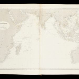
Océan Indien

event1889

location_onBrunei, Cambodia, East Timor, Indonesia, Laos, Malaysia, Myanmar, Philippines, Singapore, Southeast Asia, Thailand, Vietnam

A nautical chart of the Indian Ocean showing bathymetry (sea depth), including in great detail around the seas and straits of Southeast Asia.

close