
Search Results

Asia noviter delineata
1630
Brunei, Cambodia, East Timor, Indonesia, Laos, Malaysia, Myanmar, Philippines, Singapore, Southeast Asia, Thailand, Vietnam
This map is illustrated with drawings of Asian people wearing traditional clothing, including representatives of Sumatra, Java and the Maluku Islands. There are also drawings of important ports such as Bantam (Banten) at the western end of Java.

Asia: ex magna orbis terre descriptione Gerardi Mercatoris desumpta, studio & industria G.M. Iunioris
1630
Brunei, Cambodia, East Timor, Indonesia, Laos, Malaysia, Myanmar, Philippines, Singapore, Southeast Asia, Thailand, Vietnam
Originally published in Gerardus Mercator's ‘Atlas Sive Cosmographicae Meditationes de Fabrica Mundi et Fabricati Figura’ (1595), the title of which was the first use of the word ‘atlas’ to refer to a collection of maps. This is a 1630 reprint.

India orientalis
1630
Brunei, Cambodia, Indonesia, Laos, Malaysia, Myanmar, Philippines, Singapore, Thailand, Vietnam
As was common in this era, this map mistakenly shows the bottom of Peninsula Malaya as a separate island. The map also features illustrations of ships and a sea monster. Latin text on the reverse describes the people, crops, geography of the region.

Insulæ Indiæ orientalis
1630
Brunei, Cambodia, East Timor, Indonesia, Laos, Malaysia, Myanmar, Philippines, Singapore, Southeast Asia, Thailand, Vietnam
The southern coast of Java ('Iava Maior') on this map is represented by a dotted line, indicating that the exact coastline was unknown at this time. French text on the reverse describes the geography, crops, animals etc. of the Maluku Islands.
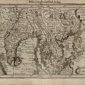
India orientalis
1630
Brunei, Cambodia, Indonesia, Laos, Malaysia, Myanmar, Philippines, Singapore, Southeast Asia, Thailand, Vietnam
Four long rivers flow south through mainland Southeast Asia on this map: the ‘Menan’, ‘Manthabam’ and ‘Cosmin’ originate at a mythical lake (‘Chiamai Lacus’) in southern China, while the ‘Mecon’ (Mekong) flows from the hills of Cochinchina (Vietnam).
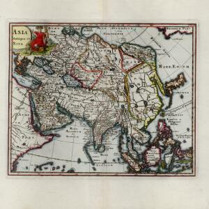
Asia antiqua et nova
c.1624-1700
Brunei, Cambodia, Indonesia, Laos, Malaysia, Myanmar, Philippines, Singapore, Southeast Asia, Thailand, Vietnam
This 17th century map of Asia features a colourful painting of an Asian man wearing bright red robes and a feathered headdress. A parrot perches on his chair, while a large cat-like creature crouches menacingly by his side.

Insulæ Indiæ orientalis præcipuæ: in quibus Moluccæ celeberrimæ sunt
1623
Brunei, Cambodia, East Timor, Indonesia, Laos, Malaysia, Myanmar, Philippines, Singapore, Southeast Asia, Thailand, Vietnam
On the right of this map, Latin text held within an elaborate border notes that five of the Maluku Islands are located nearby—Ternate, Tidore, Moti, Makian and Bacan—which trade spices including clove, cinnamon, nutmeg and ginger to the world.
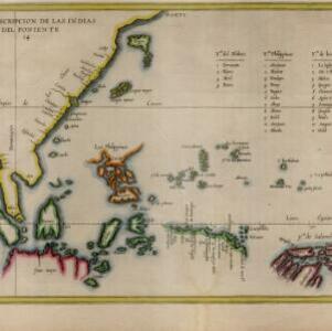
Descripcion de las Indias del Poniente
1623
Brunei, Cambodia, Indonesia, Philippines, Malaysia, Singapore, Thailand, Vietnam
The many inaccuracies and omissions on this early map of Southeast Asia show the limitations of geographical knowledge at the time. There are some interesting details though, such as a legend listing the small islands in the Moluccas and Philippines.

Mar di India
1619
Brunei, Cambodia, East Timor, Indonesia, Laos, Malaysia, Myanmar, Philippines, Singapore, Southeast Asia, Thailand, Vietnam
An early map of Southeast Asia featuring a rhumbline network, a web of lines to help plot routes and aid navigation. Where the lines meet, there is a compass rose with an arrow pointing north. The map is decorated with illustrations of sea monsters.

Malacca
1616
Brunei, Cambodia, Indonesia, Laos, Malaysia, Myanmar, Singapore, Thailand, Vietnam
French text on the back of this map of mainland Southeast Asia describes the kingdom of Pegu (Myanmar), its royal palace, ports and trade with Sumatra and Malacca (rice, butter, oil, salt, onions, silver, porcelain, quicksilver, copper, pewter etc.).

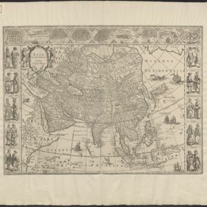
Tabula geograph in qua Europae, Africae, Asiaeq et circujacentium insularum orae maritimae accurate describuntur et ad jntelligentia navigationum Indicaru accommodantur
1614
Brunei, Cambodia, East Timor, Indonesia, Laos, Malaysia, Myanmar, Vietnam, Thailand, Southeast Asia, Singapore, Philippines
A map decorated with drawings of indigenous people, including from Southeast Asia: a Moluccan soldier with a helmet, sword and shield; a Javanese warrior with a spear and shield; a Sumatran woman holding a flower; and a Malaccan man with a sword.
- Filter from 1535 to 1900
- Latin177
- French176
- Dutch154
- English154
- German66
- Italian20
- Spanish3
- Portuguese1
- more Language »
- Indonesia687
- Malaysia632
- Brunei598
- Singapore590
- Philippines553
- Thailand544
- Cambodia543
- Vietnam541
- East Timor516
- Myanmar506
- Laos505
- Southeast Asia494
- more Simple Location »
- [remove]Borneo693
- Sumatra614
- Java567
- Sulawesi495
- Malay Peninsula454
- Celebes423
- Western New Guinea327
- Maluku Islands315
- Siam288
- Sunda Islands243
- Malacca231
- South China Sea218
- more Detailed Location »


