
Search Results
44 Results found


Ostindische Inseln
c.1870
Brunei, Cambodia, East Timor, Indonesia, Laos, Malaysia, Myanmar, Philippines, Singapore, Southeast Asia, Thailand, Vietnam
On this map of Southeast Asia, borders are outlined and cities underlined in different colours to show the colonial territories of the European powers. On Borneo, the names of indigenous peoples are listed (‘Dayak’s, Papua’s, Bugi’s’).

Kaart der Nederlandsche bezittingen in Oostindien = Possessions hollanaises aux Indes Orientales
1840
Brunei, East Timor, Indonesia, Malaysia, Singapore
Map of Dutch colonial territory in Southeast Asia, including the administrative areas of Java and Madura. Two maritime routes are marked from Batavia to the Maluku Islands: of the brig ‘Douga’ in 1825, and by Baron Godert van der Capellen in 1824.
Carte des possessions et etablissemens du Roi des Pays-Bas aux Indes Orientales
1839
Brunei, East Timor, Indonesia, Malaysia, Singapore
Map of the Dutch East Indies featuring maritime routes from the Sunda Strait and Batavia (Jakarta) to the Maluku or Spice Islands (Ambon, Ternate etc.). There is an eastern route (taken from October to March) and a return route (December to March).

East India Islands
1839
Vietnam, Myanmar, Papua New Guinea, Philippines, Singapore, Southeast Asia, Thailand, Malaysia, Laos, Indonesia, East Timor, Cambodia, Brunei
The shoals and reefs of maritime Southeast Asia are highlighted on this colourful mid-19th century map, with the treacherous waters around many islands and straits marked.

Charte de l'Asie
1800
Brunei, Cambodia, East Timor, Indonesia, Laos, Malaysia, Myanmar, Papua New Guinea, Philippines, Singapore, Southeast Asia, Thailand, Vietnam
The cartouche on this early 19th century map of Asia features a drawing of an Asian merchant smoking a long pipe while standing with his goods. Behind are a camel and an elephant surrounded by greenery and palm trees.

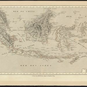
East Indies
c.1800-1899
Brunei, Cambodia, East Timor, Indonesia, Laos, Malaysia, Myanmar, Philippines, Singapore, Southeast Asia, Thailand, Vietnam
Longitude is indicated in two different ways on this mid-18th century map: along the top border, it is shown in degrees (number of degrees east of London); more unusually, along the bottom border, it is shown in time (number of hours east of London).

- Filter from 1702 to 1890
- [remove]Celebes44
- [remove]Malacca44
- [remove]Sulawesi44
- Sumatra44
- [remove]Sunda Islands44
- Borneo43
- Java42
- Siam34
- Maluku Islands31
- Malay Peninsula29
- Western New Guinea20
- Pegu17
- more Detailed Location »


