
Search Results


Nederlandsch Oost-Indië
1840
Brunei, East Timor, Indonesia, Malaysia, Papua New Guinea, Philippines, Singapore
The Dutch East Indies are bordered in red on this mid-19th century map. A maritime postal route from China to Europe, via Singapore and Penang, is shown. Another maritime route, from Batavia to Singapore, is also marked.

Kaart der Nederlandsche bezittingen in Oostindien = Possessions hollanaises aux Indes Orientales
1840
Brunei, East Timor, Indonesia, Malaysia, Singapore
Map of Dutch colonial territory in Southeast Asia, including the administrative areas of Java and Madura. Two maritime routes are marked from Batavia to the Maluku Islands: of the brig ‘Douga’ in 1825, and by Baron Godert van der Capellen in 1824.

Algemeene kaart van Nederlandsch Oostindie
c.1839-1855
East Timor, Indonesia, Malaysia, Singapore
This map of the Dutch East Indies is spread over eight sheets, with a hand-drawn cover sheet showing the whole area. There are numerous inset maps of islands, bays, cities etc. Two of the inset maps have a replacement map pasted over them.

Eastern islands or Malay archipelago
1836
Brunei, Cambodia, East Timor, Indonesia, Laos, Malaysia, Myanmar, Philippines, Singapore, Southeast Asia, Vietnam, Thailand
Brief notes printed on this 19th century map of Southeast Asia provide details about each region, including: numbers and ethnicity of the population, local or colonial rulers, crops and products, geography (corals, forests, volcanos, earthquakes).

Reduzirte Karte vom Sunda- oder Borneo-Meere
1835
Indonesia, Malaysia
A navigation map of the Java Sea and Sunda Islands, with bathymetry (sea depth), maritime routes, shoals and reefs, and elevations (side views of terrestrial landmarks). Inset maps feature the bay at Batavia and the straits between the Sunda Islands.

Reduzirte Karte vom Sunda- oder Borneo-Meere
1835
Malaysia, Indonesia
A navigation map of the Java Sea and Sunda Islands, with bathymetry (sea depth), maritime routes, shoals and reefs, and elevations (side views of terrestrial landmarks). Inset maps feature the bay at Batavia and the straits between the Sunda Islands.
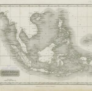
East India Islands
1817
Brunei, Cambodia, East Timor, Indonesia, Laos, Malaysia, Myanmar, Philippines, Singapore, Southeast Asia, Thailand, Vietnam
Although there is not much detail on this early 19th century map of Southeast Asia, in addition to place names, some rivers and ports are named, and there is even a ‘Dutch Factory’ on the west coast of Malaya.

A map of the East-Indies and the adjacent countries: with the settlements, factories and territories, explaning what belongs to England, Spain, France, Holland, Denmark, Portugal &c.
1720
Brunei, Cambodia, East Timor, Indonesia, Laos, Malaysia, Myanmar, Philippines, Vietnam, Thailand, Southeast Asia, Singapore
This map showcases the colonial territories of Southeast Asia in the 18th century, with text detailing trading information and the products of each region. There are five inset maps featuring plans of specific trading ports.
- [remove]Indonesia31
- Malaysia25
- East Timor23
- Singapore21
- Brunei19
- Philippines18
- Cambodia16
- Laos16
- Myanmar16
- Southeast Asia16
- Thailand16
- Vietnam16
- more Simple Location »


