
Search Results

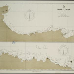
Noordkust Celebes: Hoek Kandi tot hoek Dondo
1899
Indonesia
Two navigation maps for the north coast of Celebes (Sulawesi), featuring bathymetry (sea depth), landmark mountains, reefs and shoals. Obstructions in the water are marked ‘kr’ (coral), ‘m’ (mud), ‘s’ (shells), ‘st’ (stones), and ‘z’ (sand).


Noordkust Celebes: Hoek Samija tot hoek Doelang
1899
Indonesia
A navigation map for the north coast of Celebes (Sulawesi), featuring bathymetry (sea depth), reefs and shoals. Obstructions in the water are marked ‘kr’ (coral), ‘m’ (mud), ‘st’ (stones), and ‘z’ (sand). Five additional maps show details of rivers.


Westkust Celebes: Vaarwaters benoorden Makasser: Blad II
1898
Indonesia
Navigation map of the west coast of Celebes (Sulawesi), north of Makassar. Bathymetry (sea depth), shoals and other obstructions are marked, with hills and settlements as landmarks, and elevations (side views of hills) to aid navigation.

Westkust Celebes: Vaarwaters benoorden Makasser: Blad I
1898
Indonesia
Navigation map of the west coast of Celebes (Sulawesi), north of Makassar. Bathymetry (sea depth), lighthouses, shoals and other obstructions are marked, with trees and hills as landmarks, and elevations (side views of hills) to aid navigation.

Westkust Celebes: Vaarwaters benoorden Makasser: Blad III
1898
Indonesia
Navigation map of the west coast of Celebes (Sulawesi), north of Makassar. Bathymetry (sea depth), shoals and other obstructions are marked, with hills and settlements as landmarks, and elevations (side views of hills) to aid navigation.

Vaarwaters en ankerplaatsen op de Zuidkust van Celebes
1896
Indonesia
Eight navigation maps from around the south coast of Celebes (Sulawesi). Anchorages, roadsteads (bodies of water sheltered from tides/currents), bathymetry (sea depth), shoals and other obstructions are shown, with hills and settlements as landmarks.

Kaart van den Nederlandsch-Indischen Archipel
1890
Indonesia, East Timor, Brunei, Cambodia, Malaysia, Philippines, Singapore, Southeast Asia, Thailand, Vietnam
The seas of the Dutch East Indies are the focus of this map, with maritime routes, sea temperature, sea depth, currents and monsoons shown. There are graphs of population by ethnicity, agriculture and livestock, trade and shipping, and trade exports.

Kaart van de Golf van Tomini of Gorontalo en omliggende landen
1878
Indonesia
Map of the Minahasa and East peninsulas of Celebes (Sulawesi) focusing on the road system (shown by red lines). There are four inset maps, including one showing indigenous tribal areas, and a list of places with their latitude, longitude and height.
- [remove]Celebes105
- Sulawesi105
- Borneo93
- Sumatra91
- Java88
- Malay Peninsula78
- Siam65
- Pegu64
- Malacca54
- Western New Guinea52
- Iava49
- East Indies34
- more Detailed Location »


