Search

Search Results

Upper Burma

event1898

location_onMyanmar, Thailand

Map of Upper Burma divided into Divisions and Districts, and featuring the Irrawaddy and Chindwin rivers, the Burma State Railway, and settlements including the city of Mandalay.

Upper Burma: With additions and corrections to 1896

event1896

location_onMyanmar

Map of Upper Burma divided into Divisions and Districts, and featuring the Irrawaddy and Chindwin rivers, the Burma State Railway, and settlements including the city of Mandalay.

Upper Burma: With additions and corrections to January 1894

event1894

location_onMyanmar

Map of Upper Burma divided into Divisions and Districts, and featuring the Irrawaddy and Chindwin rivers, the Burma State Railway, and settlements including the city of Mandalay.

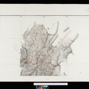
Portion of coal fields tract: Upper Chindwin district

event1892

location_onMyanmar

A map surveying coal fields close to the Chindwin River in Upper Burma (Myanmar). Mountains are shown by using hachures: short lines/dashes that give a sense of the shape and steepness of terrain. Survey stations are marked with their height.

Eastern Naga Hills and Manipur with adjoining portions of Burmah

event1882

location_onMyanmar

This map shows the border between British India and Burmah (Myanmar). Although the Burmah part of the map is mostly blank, the Chindwin River is shown, along with some other details including a label stating ‘Low hills Covered with dense Forest’.

close

  • Filter from 1883 to 1898

Current results range from 1883 to 1898