
Search Results
13 Results found


Kaart van Nederlandsch-Indie
1893
Brunei, Cambodia, Indonesia, Malaysia, Singapore, Thailand, Vietnam, East Timor, Philippines, Southeast Asia
Shipping routes are the focus of this map of the Dutch East Indies, indicated by red lines labelled with the name of the shipping company and the destinations. Parcel shipping routes are also shown. Inset maps feature railway lines too.

Kaart van den Nederlandsch-Indischen Archipel
1890
Indonesia, East Timor, Brunei, Cambodia, Malaysia, Philippines, Singapore, Southeast Asia, Thailand, Vietnam
The seas of the Dutch East Indies are the focus of this map, with maritime routes, sea temperature, sea depth, currents and monsoons shown. There are graphs of population by ethnicity, agriculture and livestock, trade and shipping, and trade exports.


Kaart van het eiland Java uit de nieuwste bronnen zamengesteld
1855
Indonesia
Map of Java divided into administrative areas (‘residencies’ and ‘regencies’). Mountains are represented by hachures, short lines/dashes that give a sense of the shape and steepness of terrain. Postal routes and roads are also marked.
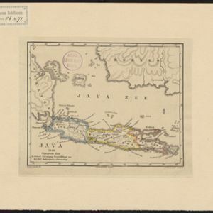

Nederlands Oostindische bezittingen, 1848
1848
Brunei, East Timor, Indonesia, Malaysia, Philippines, Singapore
Map of the Dutch East Indies, with blue borders showing the extent of Dutch colonial territory in 1848. It was published by the North Holland Regional Association of the Dutch Teachers' Association.

Kaart van de Nederlandsche bezittingen in Oost-Indië
1842
Brunei, East Timor, Indonesia, Malaysia, Philippines, Singapore
This map shows the Dutch colonial possessions in the East Indies in the mid-19th century. Other country’s colonial territories are also shown: British (Malacca), Spanish (Philippines) and Portuguese (East Timor). Forts are also marked.
- [remove]Dutch East Indies13
- [remove]Java Sea13
- Borneo11
- Java10
- Sumatra10
- Sulawesi9
- Celebes8
- Malay Peninsula7
- Banda Sea6
- Celebes Sea6
- Maluku Islands6
- South China Sea6
- more Detailed Location »


