Search

Search Results

Hoofdplaats-Medan

event1895

location_onIndonesia

Map of the city of Medan on the north coast of Sumatra, featuring the Deli and Babura rivers and two railway lines. Other notable locations include a race track, military camp, Sultan’s palace (Maimun Palace), police station, offices, hospitals etc.

Topographische kaart der residentie Tegal

event1895

location_onIndonesia

The lower half of this two-sheet topographic map of the residency of Tegal, Central Java is dominated by mountains, with the upper half split between forests and rice paddies, and the larger settlements near the coast.

Topographische kaart van het eiland Billiton: vluchtig opgenomen in de jaren 1877-1878

event1894

location_onIndonesia

This map of the island of Billiton (Belitung, Indonesia) features mountains, rivers, railways, roads, settlements, coconut plantations and administrative borders. An inset map shows the island’s port and capital city Tanjung Pandan.

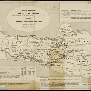
Spoor- en tramwegkaart van Java en Madoera

event1894

location_onIndonesia

The railways and tramways of Java and Madoera (Madura) are shown on this late 19th century map, including lines in use, under construction, and being planned. Each line is named, with their route, length, track gauge and construction costs listed.

Westkust Sumatra van Roesa tot Melaboe

event1894

location_onIndonesia

Navigation map of the northwest coast of Sumatra. Bathymetry (sea depth), anchor points, shoals and other obstructions (clay, coral, mud, stones, sand) are marked, with hills and settlements to use as landmarks.

Schets-taalkaart van Celebes

event1894

location_onIndonesia

This map is colour-coded to show the dozens of different languages and dialects spoken on Celebes (Sulawesi) and the surrounding islands in the late 19th century.

Kaart van Lombok

event1894

location_onIndonesia

Map of Lombok in the Lesser Sunda Islands published by the Dutch newspaper ‘Ierseksche en Thoolsche Courant’. It mainly focuses on roads and paths between the larger settlements, with rivers and mountains also marked.

Topographische kaart van het eiland Biliton

event1894

location_onIndonesia

This map of the island of Billiton (Belitung, Indonesia) features mountains, rivers, railways, roads, settlements, coconut plantations and administrative borders. An inset map shows the island’s port and capital city Tanjung Pandan.

Straat Riouw: Trigonometrisch opgenomen door het Engelsche opnemings vaartuig

event1894

location_onIndonesia

Navigation map of the Riau Strait between Batam, Bintan and Rempang (Riau Archipelago). Bathymetry (sea depth), lighthouses, bouys, currents and obstructions are marked. There are side views of islands and mountains (elevations) to use as landmarks.

Kaart van Groot Atjeh

event1894

location_onIndonesia

This map of Groot Atjeh (Aceh, northern Sumatra) focuses on Dutch military posts in and around the city of Kota Radja (Banda Aceh) during the Aceh War. It shows new permanent and temporary posts being added over the period 1884 to 1893.

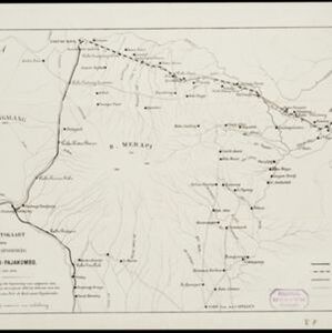
Overzichtskaart van den ontworpen spoorweg Fort de Kock-Pajakombo

event1894

location_onIndonesia

A map of railway lines between Fort de Kock (Bukittinggi) and Pajakombo (Payakumbuh) in western Sumatra. The map includes existing line, planned line and rack railway line (a line with a rack and pinion system so it can operate on steep slopes).

Residentie Preanger Regentschappen

event1894

location_onIndonesia

Large-scale topographic map of the residency of Preanger (West Java) spread over multiple sheets plus a cover sheet of the whole area. It is divided into regencies, departments and districts. Only nine sheets and the cover sheet are available.

close