
Search Results
468 Results found

Schetze van de bank met derzelver uitbreiding zedert 1817 voor de Groote rivier te Batavia, benevens de geprojekteerde en gedeeltelijk geexecuteerde zee-hoofden
1823
Indonesia
Plan of improvements made to the pier at the port in Batavia (Jakarta): red lines show new parts added in 1822; numbers record the change in water depth (red is 1818; black is 1823). Planned future works and the ‘Waterkasteel’ fort are also shown.
Schetze van de bank voor de Groote rivier te Batavia, met de geprojekteerde en gedeeltelijk geexecuteerde zee hoofden
1823
Indonesia
Plan of improvements to the pier at the port in Batavia (Jakarta): new parts added in 1822 are labelled AB; numbers record the change in water depth (red is before the improvements; black is after). Planned future works (labelled BC) are also shown.
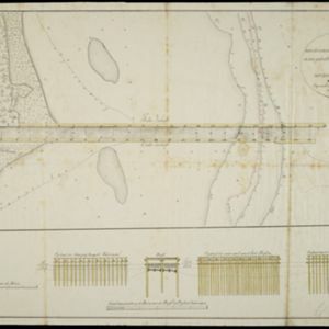
Schetze van de nieuwgemaakte zeehoofden en een gedeelte der bank voor de Groote rivier te Batavia met derzelver uitbreiding zedert 1817 tot 1823
1823
Indonesia
Plan of improvements made to the pier at the port in Batavia (Jakarta), including profile drawings of the construction parts. Lines indicate the changing position of the beach and the sandbank over the years, and numbers show the water depth.

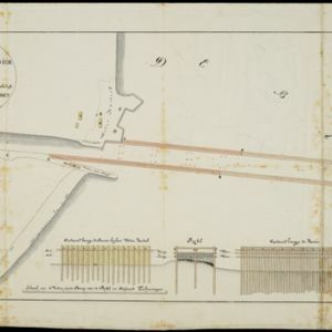
Schets der verrigte werkzaamheden aan de zee hoofden op de bank voor de Groote rivier te Batavia
1822
Indonesia
Plan of improvements made to the pier at the port in Batavia (Jakarta): red lines show new parts added in 1822; numbers record the change in water depth (red is 1818; black is 1822). Planned future works and the ‘Waterkasteel’ fort are also shown.

The North Coast of Java, from Madura to Samarang
1818
Indonesia
Chart of the north coast of Java, featuring a rhumbline network—a web of lines to help plot routes—bathymetry (sea depth), shoals, reefs and side views of landmark mountains (elevations), all to aid navigation. With an inset map of nearby islands.


Situatie-kaart van een gedeelte der stad Batavia benevens de bank voor de Groote rivier
1817
Indonesia
Plan of the canals and rivers flowing through the city of Batavia (Jakarta), passing through the port before reaching the pier and the bay. The bay has a sand bank and figures for water depth. There are profile drawings of two of the city’s rivers.


The landing of the British Army at Chillinching on the island of Java 4th Augt. 1811
1815
Indonesia
A map of the landing of British troops at Chillinching (Cilincing, 12 miles to the east of Batavia), part of the 1811 invasion of Java during the Napoleonic Wars. The frigate Leda is at the river mouth, as the British soldiers row to shore.
- Filter from 1700 to 1900
- [remove]Dutch East Indies468
- Java235
- Sumatra172
- Borneo89
- Sulawesi85
- Celebes82
- Java Sea57
- Batavia50
- Jakarta49
- Malay Peninsula49
- Maluku Islands42
- Western New Guinea41
- more Detailed Location »
- Port73
- Railway Station46
- Pier40
- River379
- Road263
- Path164
- Railway/Tramway95
- Postal Route92
- Canal51
- Bridge40
- Telegraph/Telephone30


