
Search Results
468 Results found


Overzichtskaart van Groot-Atjeh en aangrenzende kuststaten
1898
Indonesia
Map of Groot-Atjeh (Aceh, Sumatra), focusing on the area around the capital Kota Radja (Banda Aceh) and along the coasts. There is a list of telephone connections in the area, and an inset map of the region divided into administrative districts.

Plattegrond van de stad en casteel Batavia, met de daarnaast gelegene situatie
1898
Indonesia
Plan of the port city of Batavia (Jakarta) with the pier (and North) at the bottom. There is a legend, and an illustrated cartouche featuring a female figure holding an oar and a shield decorated with the ‘VOC’ logo of the Dutch East India Company.
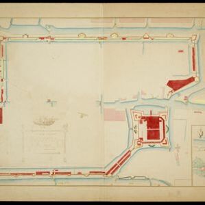
Plattegrondtekening der vestingwerken van de stad en 't kasteel Batavia
1898
Indonesia
Hand-drawn and coloured plan of the fortifications at Batavia (Jakarta, Java) including the castle, city walls, and moat and canal system. An inset map features four more of the city’s fortifications. This is a copy of an original 1788 map.

Riouw archipel: Straat Doerian en oostelijke vaarwaters
1898
Indonesia
Navigation map of the waters and straits around some of the islands of the Riau Archipelago, between Sumatra and Batam. Bathymetry (sea depth), current and tide data, reefs, shoals and other obstructions (clay, mud, shells, stones, sand) are marked.


Schetze van de stad Batavia, voorsteden en Chineesche kamp, dienende ter aanwijzing der rivieren en grachten... moeten worden uitgediept, uitgegraven of gedempt
1898
Indonesia
Plan of the city of Batavia (Jakarta) and its suburbs. Based on a report on health conditions in the city, it shows where the rivers and canals need to be deepened, excavated or filled in.

Situatie plan van Batavia met desselfs stranden en ommelanden tot de buiten posten Angiol, Noortwijk, Rijswijk, de Kelling , Ankee en de Fluit
1898
Indonesia
Plan of the city of Batavia (Jakarta) with its suburbs and surrounding areas. Artillery batteries are marked on the beaches, and there is a detailed legend identifying places on the map. This is a copy of an original 1797 map.

Situatieplan van Batavia desselfs stranden en ommelanden
1898
Indonesia
Plan of the city of Batavia (Jakarta), its suburbs and surrounding areas, focussing on the river and canal system. This is a copy of an original c.1790 map. The pier has been pencilled in, as it was not built when the original map was produced.


De stad Batavia met derzelver omstreken: Geteekend in 1826
1898
Indonesia
The city of Batavia (Jakarta) with its port and castle is to the north (right side of the map). Koningsplein (Merdeka Square), a large area of rice paddies, graveyards and villages can be seen to the south (left). Copied from a c.1826 map.
- Filter from 1700 to 1900
- [remove]Dutch East Indies468
- Java235
- Sumatra172
- Borneo89
- Sulawesi85
- Celebes82
- Java Sea57
- Batavia50
- Jakarta49
- Malay Peninsula49
- Maluku Islands42
- Western New Guinea41
- more Detailed Location »
- Port73
- Railway Station46
- Pier40
- River379
- Road263
- Path164
- Railway/Tramway95
- Postal Route92
- Canal51
- Bridge40
- Telegraph/Telephone30


