Search

Search Results

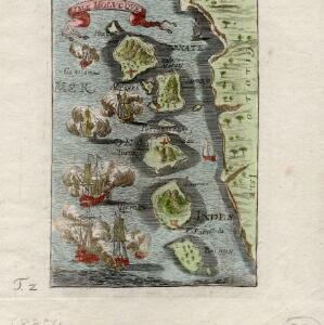
[Dutch portolan chart of the eastern Dutch East Indies]

event1700

location_onIndonesia, East Timor

This colourful hand-drawn portolan (nautical) chart was designed to aid navigation. It features a rhumbline network (the web of interconnected lines), bathymetry (sea depth), shoals and reefs, anchor points and written notes.

Delineatio Indiæ orientalis: quae lumen dabit huic itinerario et historiis

event1700

location_onBrunei, Cambodia, Indonesia, Laos, Malaysia, Myanmar, Philippines, Singapore, Southeast Asia, Thailand, Vietnam

This map of India and Southeast Asia—or ‘Indiae Orientalis [East Indies]’ as it was called at the time—was published in a book documenting the travels of the German scholar and geographer Adam Olearius (1599–1671).

[Globe gore covering East Asia]

eventc.1693-1701

location_onIndonesia, Philippines

The written notes on this map describe the discovery and conquest of the Philippines by the Spanish, and also emphasise the importance of trade in the region. Illustrations of trading ships on the sea reinforce the trade theme.

Le Molucche

event1692

location_onIndonesia

Map of a small island chain off the west coast of Gilolo (modern Halmahera in the Maluku Islands, Indonesia). Italian text describes the larger islands (Ternate and Tidore) and the Philippines. From Vicenzo Coronelli's ‘Corso Geografico Universale’.

Isole dell'Indie divise in Filippine, Molucche e della Sonda

eventc.1691-1696

location_onBrunei, Cambodia, East Timor, Indonesia, Laos, Malaysia, Myanmar, Philippines, Singapore, Southeast Asia, Thailand, Vietnam

Dotted lines and colours divide maritime Southeast Asia into three regions on this map: the Philippine archipelago, Maluku Islands and Sunda Islands. The cartouche features cherub mermaids carrying a banner and shield.

Isle Molvcqves

event1684

location_onIndonesia

The islands on this map were central to conflicts between the European powers over the valuable spice trade of the Maluku or ‘Spice’ Islands. A sea battle between European ships is shown, and there are military forts marked in red on the islands.

Isles de la Sonde vers l'Orient

event1683

location_onEast Timor, Indonesia, Philippines

French text on the reverse of this map of the eastern Sunda Islands describes the city of Macassar (modern Makassar) on Celebes (Sulawesi, Indonesia). Details include the city’s port, trade and crops, as well as its people and religion.

Isole dell'Indie divise in Filippine, Molucche e della Sonda

event1680

location_onBrunei, Cambodia, East Timor, Indonesia, Malaysia, Laos, Myanmar, Philippines, Singapore, Southeast Asia, Thailand, Vietnam

Dotted lines and colours divide maritime Southeast Asia into three regions on this map: the Philippine archipelago, Maluku Islands and Sunda Islands. The cartouche features cherub mermaids, and a map of mainland Southeast Asia is on the reverse.

The Molucca Ilands &c.

eventc.1680-1700

location_onEast Timor, Indonesia, Philippines

From Robert Morden’s ‘Geography Rectified’, a description with maps of the known world in the late 17th century. The map shows the Moluccas, but the text describes the Philippines: Spanish colonial rule, trade, the city of Manila and port of Cavite.

Asiæ nova descriptio

event1660

location_onBrunei, Cambodia, East Timor, Indonesia, Laos, Malaysia, Myanmar, Singapore, Philippines, Southeast Asia, Thailand, Vietnam

This mid-17th century map of Asia is illustrated with drawings of Asian people wearing traditional clothing, including a man and woman from Java in Southeast Asia. There are also drawings and plans of important Asian cities.

India orientalis

event1658

location_onBrunei, Cambodia, East Timor, Indonesia, Laos, Malaysia, Myanmar, Philippines, Singapore, Thailand, Southeast Asia, Vietnam

This mid-17th century map features three long rivers flowing south through mainland Southeast Asia. Their source is a lake named ‘Chiamai Lacus’, which was one of a number of mythical lakes once thought to exist in southern China.

Asiæ nova delineatio

eventc.1656-1677

location_onBrunei, Cambodia, East Timor, Indonesia, Laos, Malaysia, Myanmar, Philippines, Singapore, Southeast Asia, Thailand, Vietnam

This colourful mid-17th century map was originally published in the Dutch cartographer Nicolaes Visscher's ‘Atlas contractus’. The map is dedicated to D. Henry Spiegel, consul and senator of the city of Amsterdam, and features his coat of arms.

close