
Search Results
9 Results found


Map to illustrate the operations about Sadon, Upper Burma
1891
Myanmar
Map of northeast Burma (Myanmar) bordering China's Yunnan Province. The title refers to ‘operations’ around the town of Sadon, possibly part of the Burmese resistance movement against British colonial rule in the late 19th century.

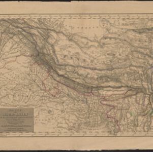
Karte von Hoch-Asien: zu C. Ritter's Erdkunde, Buch II, Asien
1833
Myanmar
Four-sheet map of Asia from Carl Ritter’s book ‘Erdkunde [Geography]’, including the northwest Birman Empire (Myanmar) and featuring rivers, mountains, administrative districts and settlements. Plus a page of elevations of Asian mountain ranges.
- Filter from 1833 to 1898
- [remove]District/Administrative Border9
- [remove]National Border9
- Colonial Possessions2


