Search

Search Results

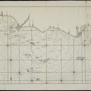
Schets van het vaarwater naar en op de reede van Batavia

event1824

location_onIndonesia

This early 19th century map shows the islands, shoals and reefs in the harbour of the important port city of Batavia (Jakarta) in the Dutch East Indies. Individual islands and reefs are named, as are the rivers and canals on land.

Kaart van het vaarwater naar en op de reede van Batavia

event1824

location_onIndonesia

The ports of Batavia (Jakarta) and Bantem (Banten) feature on this navigation map of the north coast of Java. Shoals, reefs, bathymetry (sea depth, in figures) and anchor points are marked, with explanatory notes written next to some islands/reefs.

Schetze van de bank voor de Groote rivier te Batavia, met de geprojekteerde en gedeeltelijk geexecuteerde zee hoofden

event1823

location_onIndonesia

Plan of improvements to the pier at the port in Batavia (Jakarta): new parts added in 1822 are labelled AB; numbers record the change in water depth (red is before the improvements; black is after). Planned future works (labelled BC) are also shown.

Schetze van de nieuwgemaakte zeehoofden en een gedeelte der bank voor de Groote rivier te Batavia met derzelver uitbreiding zedert 1817 tot 1823

event1823

location_onIndonesia

Plan of improvements made to the pier at the port in Batavia (Jakarta), including profile drawings of the construction parts. Lines indicate the changing position of the beach and the sandbank over the years, and numbers show the water depth.

Schetze van de bank met derzelver uitbreiding zedert 1817 voor de Groote rivier te Batavia, benevens de geprojekteerde en gedeeltelijk geexecuteerde zee-hoofden

event1823

location_onIndonesia

Plan of improvements made to the pier at the port in Batavia (Jakarta): red lines show new parts added in 1822; numbers record the change in water depth (red is 1818; black is 1823). Planned future works and the ‘Waterkasteel’ fort are also shown.

Schets der verrigte werkzaamheden aan de zee hoofden op de bank voor de Groote rivier te Batavia

event1822

location_onIndonesia

Plan of improvements made to the pier at the port in Batavia (Jakarta): red lines show new parts added in 1822; numbers record the change in water depth (red is 1818; black is 1822). Planned future works and the ‘Waterkasteel’ fort are also shown.

Situatie kaart van een gedeelte der stad Batavia

event1817

location_onIndonesia

Map of the coastline of the bay of Batavia (Jakarta) showing the sand and mud bank and bathymetry (sea depth) in the bay. A plan of part of the city, including the fort, and the surrounding countryside are also included.

Situatie-kaart van een gedeelte der stad Batavia benevens de bank voor de Groote rivier

event1817

location_onIndonesia

Plan of the canals and rivers flowing through the city of Batavia (Jakarta), passing through the port before reaching the pier and the bay. The bay has a sand bank and figures for water depth. There are profile drawings of two of the city’s rivers.

Nieuwe kaart van het eiland Java

event1816

location_onIndonesia

Map of Java marked with administrative regions, settlements, roads, mountains and rivers. There is an inset map of the port city of Batavia, with its system of rivers and canals, and its surrounding country with villages, fields and plantations.

A new chart shewing the navigation through the Strait of Sunda to Batavia

event1815

location_onIndonesia

Navigation chart of the Sunda Strait, with sea depth, anchor points, shoals and other obstructions. Includes many bays, with four highlighted on inset maps. Partly based on writings of Captain Krusenstern whose 1806 route through the strait is shown.

close