
Search Results


Oostindië
1842
Brunei, Cambodia, East Timor, Indonesia, Laos, Malaysia, Myanmar, Philippines, Singapore, Southeast Asia, Thailand, Vietnam
Dutch map of the East Indies, with mountain ranges represented by simple hachure marks, and just a few rivers marked. Mainland Southeast Asia is labelled ‘Achter Indie [Beyond India]’.
Kaart van de Nederlandsche bezittingen in Oost-Indië
1842
Brunei, East Timor, Indonesia, Malaysia, Philippines, Singapore
This map shows the Dutch colonial possessions in the East Indies in the mid-19th century. Other country’s colonial territories are also shown: British (Malacca), Spanish (Philippines) and Portuguese (East Timor). Forts are also marked.
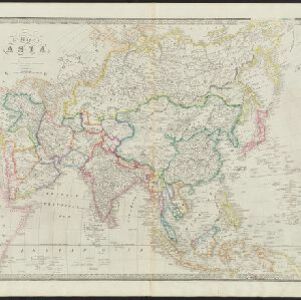
Map of Asia
1840
Brunei, Cambodia, East Timor, Indonesia, Laos, Malaysia, Myanmar, Papua New Guinea, Philippines, Singapore, Southeast Asia, Thailand, Vietnam
On this mid-19th century map of Asia, national and regional borders are colour-coded, including colonial possessions such at the British Straits Settlements. Coastal cities, islands, shoals and reefs are marked in detail.

Kaart van de Nederlandsche bezittingen in Oost-Indië
1840
Brunei, East Timor, Indonesia, Malaysia, Philippines, Singapore
This map shows the Dutch colonial possessions in the East Indies in the mid-19th century. The text provides great detail about the people, religion, crops, animals, geography and administration of the Dutch East Indies.

Nederlandsch Oost-Indië
1840
Brunei, East Timor, Indonesia, Malaysia, Papua New Guinea, Philippines, Singapore
The Dutch East Indies are bordered in red on this mid-19th century map. A maritime postal route from China to Europe, via Singapore and Penang, is shown. Another maritime route, from Batavia to Singapore, is also marked.

Asia cum omnibus Imperiis, Provinciis, Statibus et Insulis correcta et adornata
1840
Brunei, Cambodia, East Timor, Indonesia, Laos, Malaysia, Myanmar, Papua New Guinea, Philippines, Singapore, Southeast Asia, Thailand, Vietnam
This colourful map of Asia has an elaborate cartouche featuring two Asian men talking—one carries a bow, the other smokes a long pipe—while a lion sits nearby. The scale is also illustrated, with drawings of Asian birds.

Kaart der Nederlandsche bezittingen in Oostindien = Possessions hollanaises aux Indes Orientales
1840
Brunei, East Timor, Indonesia, Malaysia, Singapore
Map of Dutch colonial territory in Southeast Asia, including the administrative areas of Java and Madura. Two maritime routes are marked from Batavia to the Maluku Islands: of the brig ‘Douga’ in 1825, and by Baron Godert van der Capellen in 1824.
Asia cum omnibus Imperiis, Provinciis, Statibus et Insulis correcta et adornata
1840
Brunei, Cambodia, East Timor, Indonesia, Laos, Malaysia, Myanmar, Papua New Guinea, Philippines, Singapore, Southeast Asia, Thailand, Vietnam
This colourful map of Asia has an elaborate cartouche featuring two Asian men talking—one carries a bow, the other smokes a long pipe—while a lion sits nearby. The scale is also illustrated, with drawings of Asian birds.
Kaart der Nederlandsche bezittingen in Oostindien = Possessions hollanaises aux Indes Orientales
1840
Brunei, East Timor, Indonesia, Malaysia, Singapore
Map of Dutch colonial territory in Southeast Asia, including the administrative areas of Java and Madura. Two maritime routes are marked from Batavia to the Maluku Islands: of the brig ‘Douga’ in 1825, and by Baron Godert van der Capellen in 1824.

Asiatic archipelago
1840
Vietnam, Myanmar, Papua New Guinea, Philippines, Singapore, Southeast Asia, Thailand, Malaysia, Laos, Indonesia, East Timor, Brunei, Cambodia
This late 19th century map of Southeast Asia shows the best maritime routes around the region, according to the time of year. There is also an inset map highlighting the rivers and southern islands of Singapore.
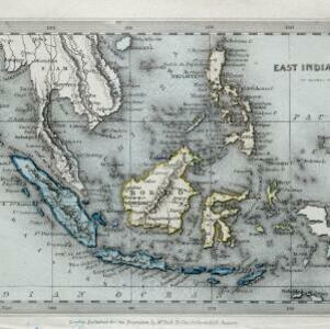
East India Islands
1840
Vietnam, Myanmar, Papua New Guinea, Philippines, Singapore, Southeast Asia, Thailand, Malaysia, Laos, Indonesia, East Timor, Cambodia, Brunei
The colonial possessions of Britain (in red, though faded on this map), the Netherlands (green, but discoloured to blue) and Spain (the Philippines, brown) are shown on this map, with independent areas such as Borneo and the Maluku Islands in yellow.
- Filter from 1565 to 1900
- Indonesia402
- Malaysia386
- Singapore380
- East Timor377
- Brunei376
- Philippines363
- Thailand347
- Cambodia345
- Vietnam341
- Southeast Asia334
- Myanmar325
- Laos323
- more Simple Location »
- [remove]Celebes402
- [remove]Java402
- Sulawesi397
- Borneo395
- Sumatra392
- Malay Peninsula307
- Western New Guinea238
- Siam216
- Maluku Islands209
- Pegu164
- Malacca161
- Sunda Islands147
- more Detailed Location »


