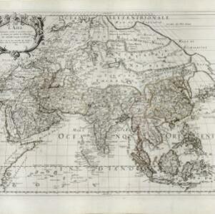
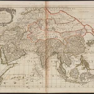
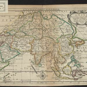
Search

Search Results

L'Asie

event1690

location_onBrunei, Cambodia, East Timor, Indonesia, Laos, Malaysia, Myanmar, Philippines, Singapore, Southeast Asia, Thailand, Vietnam

On this late 17th century map of Asia by the French cartographer Nicolas Sanson, mainland Southeast Asia is labelled ‘PresquIsle de la le Gange [Peninsula of the Ganges]’.

Isole dell'India, cioè le Molucche, le Filippine e della Sonda: parte de Paesi di nuoua scoperta e l'Isole de Ladri nel Mare del Zud

event1683

location_onBrunei, Cambodia, East Timor, Indonesia, Laos, Malaysia, Myanmar, Papua New Guinea, Philippines, Singapore, Southeast Asia, Thailand, Vietnam

Dotted lines on this late 17th century map demarcate regions and kingdoms (which also have a crown symbol). The cartouche is shaped like a giant shell supported by mermen, with cherubs holding up shells and pearls on top.

Isles de la Sonde vers l'Occident

event1683

location_onBrunei, Cambodia, Indonesia, Malaysia, Philippines, Singapore, Thailand, Vietnam

This late 17th century map of the western Sunda Islands—Sumatra, Java and Borneo—is decorated with a colourful cartouche probably featuring the Greek god Poseidon and his wife Amphitrite. Cherubs play trumpets and ride on sea monsters.

Asia divided into its principall regions in which may be seen the extent of the Empires, Monarchies, Kingdoms and States which at present divide Asia

event1680

location_onBrunei, Cambodia, East Timor, Indonesia, Laos, Malaysia, Myanmar, Papua New Guinea, Philippines, Singapore, Southeast Asia, Thailand, Vietnam

This late 17th century map of Asia is by William Berry, based on an earlier map by the French cartographer Nicolas Sanson. Dedicated to King Charles II, it features the royal coat of arms of the United Kingdom in its elaborate cartouche.

Isole dell'Indie divise in Filippine, Molucche e della Sonda

event1680

location_onBrunei, Cambodia, East Timor, Indonesia, Malaysia, Laos, Myanmar, Philippines, Singapore, Southeast Asia, Thailand, Vietnam

Dotted lines and colours divide maritime Southeast Asia into three regions on this map: the Philippine archipelago, Maluku Islands and Sunda Islands. The cartouche features cherub mermaids, and a map of mainland Southeast Asia is on the reverse.

The isles of Sonda

event1680

location_onBrunei, Indonesia, Malaysia, Singapore

From Robert Morden’s ‘Geography Rectified’, a description with maps of the known world in the late 17th century. Text describes the peoples of the uplands of the Sunda Islands as ‘Pagans’, while the coastal peoples are ‘Mahumetans [Muslims]’.

L'Asia

event1677

location_onBrunei, Cambodia, East Timor, Indonesia, Laos, Malaysia, Myanmar, Philippines, Southeast Asia, Singapore, Thailand, Vietnam

From Giovanni Giacomo de Rossi’s ‘Mercurio Geografico’, this 17th century map of Asia represents mountains, jungles and cities pictorially, with hand-coloured regional borders. The map’s cartouche is decorated with clothing and weaponry.

Asia according to ye newest observations

eventc.1670-1732

location_onBrunei, Cambodia, East Timor, Indonesia, Laos, Malaysia, Myanmar, Papua New Guinea, Philippines, Singapore, Southeast Asia, Thailand, Vietnam

A map of Asia by the London-based cartographer Herman Moll (1654?–1732) with colour-coded regional borders. In Southeast Asia, each major land mass or island has its own coloured border.

L'Asie

event1669

location_onBrunei, Cambodia, East Timor, Indonesia, Laos, Malaysia, Myanmar, Philippines, Singapore, Southeast Asia, Thailand, Vietnam

Produced by the French cartographer Nicolas Sanson (1600–1667) in the mid-17th century, this map of Asia features hand-coloured regional borders. Its cartouche features cherubim and decorative scrollwork.

L'Asie

event1652

location_onBrunei, Cambodia, East Timor, Indonesia, Laos, Malaysia, Myanmar, Philippines, Singapore, Southeast Asia, Thailand, Vietnam

On this late 17th century map of Asia by the French cartographer Nicolas Sanson, mainland Southeast Asia is labelled ‘PresquIsle de la le Gange [Peninsula of the Ganges]’.

Les Isles de la Sonde: entre lesquelles sont Sumatra, Java, Borneo &c.

eventc.1652

location_onBrunei, Indonesia, Malaysia, Singapore

This mid-17th century map of the Sunda Isles (‘Isles de la Sonde’) includes the Malay Peninsula in addition to Sumatra, Java and Borneo. Mountain ranges and jungles are shown pictorially, and the islands and coasts feature shoals and reefs.

close